The floods that inundated large parts of Pakistan during the summer of 2022, causing a huge human and economic disaster, were triggered by torrential and persistent monsoon rainfalls from mid-June through to August. ECMWF’s seasonal forecasting system SEAS5, and other seasonal prediction models from the EU’s Copernicus Climate Change Service (C3S) implemented by ECMWF, successfully predicted extreme rainfall during the summer over the affected area in forecasts issued at the beginning of May 2022.
Successful seasonal forecasts
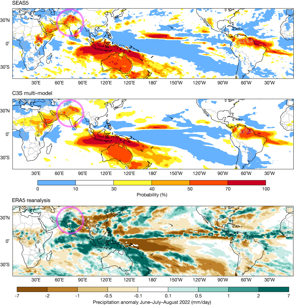
SEAS5’s forecasts for June–July–August 2022 initialised on 1 May 2022 indicated a strong signal of extreme rainfall over Pakistan. The upper panel of the figure shows the operational forecast product of the probability of being in the highest 20% of the model’s climatological distribution as an example. For Pakistan, the probability of rainfall in that highest quintile category was drastically increased to 50–70%. Our confidence in these predictions is a priori high since the SEAS5 historical hindcasts have demonstrated significant skill for high rainfall in this region and season (see https://bit.ly/3EQ5E2Q). The location and intensity of the precipitation anomaly was also well predicted at the extended forecast range (up to 46 days ahead) – see the article by Magnusson et al. in this Newsletter.
The good performance of ECMWF’s seasonal forecast was no exception amongst other forecasting systems. The C3S multi-model seasonal forecast ensemble also predicted a high probability of extreme rainfall (see the middle panel of the figure). This ensemble includes, in addition to SEAS5, forecast models from the UK Met Office, Météo-France, the Euro-Mediterranean Centre on Climate Change (CMCC) in Italy, the German National Meteorological Service (DWD), the US National Centers for Environmental Prediction (NCEP), the Japan Meteorological Agency (JMA), and Environment and Climate Change Canada (ECCC).
Consistent with these predictions, the South Asian Seasonal Climate Outlook Forum indicated a strongly increased probability of above normal June to September 2022 rainfall for Pakistan, which was followed by high alerts from Pakistan’s National Disaster Management Authority.
An estimate of precipitation anomalies from the ERA5 reanalysis is shown in the lower panel of the figure, confirming the agreement in the broad geographical location of the rain with the seasonal forecasts.
An exceptional season
The northern summer season 2022 was characterised by La Niña cold conditions in the tropical Pacific persisting for a third year in a row. The El Niño–Southern Oscillation (ENSO) is known to impact the South Asian summer monsoon, with La Niña years related to stronger cyclogenesis activity over the Bay of Bengal and higher than normal rainfall over the Indian subcontinent. Pakistan is among the countries that are enormously affected by ENSO.
Furthermore, the tropical Indian Ocean displayed a pronounced positive dipole structure during the summer, known as the Indian Ocean Dipole (IOD), with warmer-than-normal sea-surface temperatures (SSTs) in the eastern parts and colder-than-normal SSTs in the western areas of the basin. A positive IOD is associated with a stronger-than-normal South Asia southwest monsoon.
Both these large-scale tropical sea-surface anomalies were well reproduced in the seasonal forecasts from SEAS5 and C3S (see https://climate.copernicus.eu/charts/c3s_seasonal/) and likely played a vital role in the successful predictions of the Pakistan rains. Other less-well investigated potential factors that influenced the extreme precipitation include tropical Atlantic SSTs and Eurasian land heating.
These successful predictions are an example of the power of seasonal forecasts to provide early warnings and enhance resilience against climate hazards. Building confidence in the physical and computational sciences underpinning the forecasts is an important step towards improving the information value chain.