
Coupled simulations reveal that increasing the horizontal resolution of the atmosphere from 9 km in ECMWF’s operational Integrated Forecasting System (IFS) to 4.5 and 2.8 km markedly improves predictions of tropical cyclone intensity. It also improves the ocean response to the passing of a tropical cyclone. These findings come from the INCITE 2022 project, awarded to ECMWF and US Oak Ridge National Laboratory scientists to perform GPU-enabled, high-resolution simulations with the IFS on US Department of Energy (DOE) high-performance computing (HPC) resources.
Every year tropical cyclones (TCs) cause a lot of damage and deaths. For example, in the US average TC damage amounts to $20.5 billion/event and the average death toll is 159/year. Accurate forecasting of TCs is thus critical for emergency preparedness and securing infrastructures, especially in densely populated regions. A key question in the INCITE 2022 project is whether a more accurate representation of TCs in numerical weather prediction models can be achieved with an increase in the atmospheric and oceanic horizontal resolution from what is affordable today. Extreme TCs Irma, Florence, Teddy and Ida were chosen for the investigation due to their high cost to the US economy and the availability of ALAMO float observations of temperature and salinity across the TC track. The observations make it possible to validate the modelled ocean response to the passage of TCs.
Tropical cyclone intensity
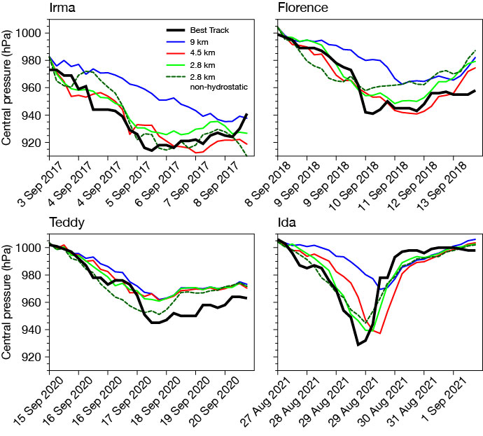
The first figure shows the positive impact of atmospheric horizontal resolution increases from 9 km to 4.5 and 2.8 km on TC intensity predictions in 7‑day IFS forecasts, coupled to a high-resolution, eddy-permitting 1/12 degree NEMO4 ocean model. The TCs are clearly more intense at higher horizontal resolution and in better agreement with observations (Best Track data). This result is expected, given that TCs are mesoscale features and therefore require high spatial resolution to be represented accurately. Interestingly, the benefit of increased horizontal resolution can already be achieved at 4.5 km, and increasing the horizontal resolution further to 2.8 km has little impact. Therefore, a future horizontal resolution upgrade to 4.5 km has the potential to significantly improve TC prediction at ECMWF. The preliminary analysis has so far shown little impact of ocean resolution to the core pressure and tracks (not shown).
Ocean representation
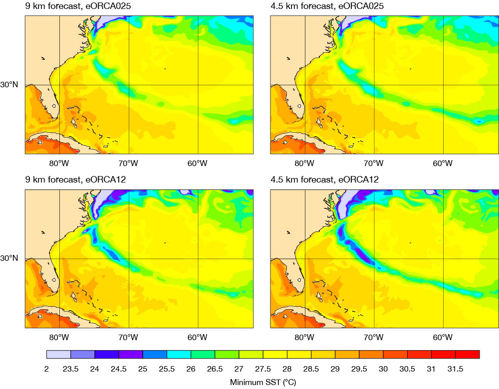
Accurately representing the ocean during the passing of TCs is important because sea-surface temperatures (SSTs) provide an energy source to the TC. Therefore, if SSTs are incorrectly represented in a forecast, erroneous predictions of TC intensity can occur. In addition to better TC intensity forecasts, an increase in atmospheric resolution is also found to result in a more accurate ocean response to the passing of a TC. In particular, the cold wake is stronger with an increase in both the atmospheric and oceanographic resolutions for some cases. An example is shown in the second figure, which shows the minimum SST over the whole integration period (7 days) for tropical cyclone Florence. Preliminary analysis also indicates that the stronger cold wake agrees better with sea-surface temperature observations (not shown).
Technical work
Performing such high-resolution atmosphere and ocean simulations requires not only a substantial scientific but also a technical effort from the INCITE 2022 team. For example, a substantial code adaptation needed to be undertaken to perform IFS spectral transform calculations on GPUs and to port the IFS model to DOE HPC platforms. Ultimately, this is part of the ECMWF-wide effort on scalability and code adaptation for future computing architectures.
Outlook
Next, the INCITE 2022 project will investigate what advantages, if any, arise for TC predictions from increasing the atmospheric spatial resolution further to 1 km. Another key question is whether the hydrostatic approximation, currently in use in operational forecasts at ECMWF, will need to be relaxed at this resolution in order to better forecast tropical cyclones. Preliminary analysis indicates that, at a grid spacing of 2.8 km, relaxing the hydrostatic approximation has a negligible effect on TC intensity forecasts (compare the dashed dark green line to the solid green line in the first figure). Future work will take place in the wider context of high-resolution modelling initiatives at ECMWF, for example in the EU-funded nextGEMS project (see the article on the water budget in this Newsletter) and the EU-funded Destination Earth initiative.
As part of the INCITE project, various hackathons are taking place to allow external users to explore the large volume of data. Recently, 1 km data was used in the Visualisation Hackathon 2022 held at ECMWF in conjunction with the Using ECMWF’s Forecasts (UEF2022) event. The next INCITE open science hackathon, organised jointly by ECMWF and the Oak Ridge Leadership Computing Facility (OLCF), will be held virtually from July to December 2022.