
A new study has used initial and lateral boundary conditions produced by ECMWF’s Integrated Forecasting System (IFS) to investigate the predictability of a highly localised heavy rain event in mountainous terrain in Armenia using a limited-area model. The study illustrates the importance of high-quality initial and boundary conditions and highlights challenges in accurately forecasting such events.
Details of the event
In the summer, heavy rainfall events in mountainous regions are often accompanied by damaging hailstorms and windstorms, flash floods or landslides, causing the loss of lives and significant economic damage. Accurately forecasting heavy rainfall events is thus important, but it poses a number of challenges. These include small spatial and temporal scales and the inherent nonlinearity of the dynamics and physics of such weather phenomena. This can be especially problematic over mountainous regions characterized by heterogeneous orography. In the afternoon of 2 July 2016, 52.8 mm of rain fell at Talin weather station in western Armenia. This is about 1.5 times higher than the climatological average for the entire month of July. The extreme rainfall lasted only 1 hour and 20 minutes and was accompanied by lightning and wind gusts reaching up to 22 m/s.
Forecasting the event
The US Weather Research and Forecasting (WRF) limited-area model was used in order to perform dynamical downscaling to a 3 km grid. The WRF model requires a minimum set of meteorological and land-surface fields for successful initialisation. The meteorological input data, known as forcing data or initial and lateral boundary conditions, include near-surface and upper-air temperature, humidity, wind, pressure etc. The following forcing data were used in the study:
- ECMWF’s high-resolution operational forecasts starting at 0000 UTC on 2 July 2016 (IFS Cycle 41r2)
- ECMWF’s new ERA5 reanalysis
- The US National Centers for Environmental Prediction (NCEP) Global Data Assimilation System Final operational analysis (GDAS FNL)
ECMWF’s high-resolution global forecast has a grid spacing of about 9 km. The other two global datasets have a coarser grid spacing (31 km and 28 km, respectively) but benefit from vast amounts of observations from satellites, aircraft, weather stations, weather balloons etc. from around the time of the rain event.
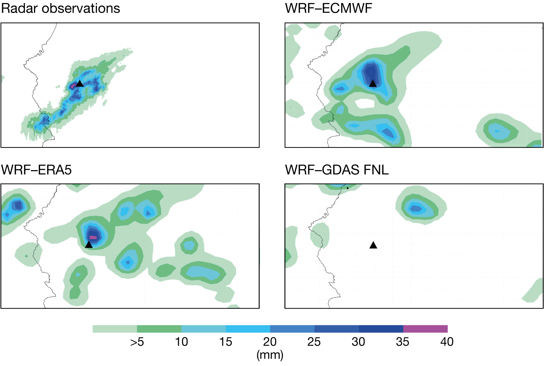
The first figure shows the geographic distribution of rainfall according to very high resolution (about 500 m grid spacing) rainfall estimates derived from radar observations and WRF forecasts using different forcing data, all between 1200 and 1400 UTC on 2 July 2016. The northeast to southwest-oriented rainfall band stretched over the southwestern slopes of Mount Aragats. The area of maximum rainfall located around Talin station (the black triangle) saw up to 40 mm of rain. High-frequency radar observations (every five minutes) show that the earliest orographic convective cells were initiated over the Aragats massif at around 0705 UTC. The convective cells then propagated downslope in a southwesterly direction toward the Talin station and beyond. At 4,090 m above sea level, Mount Aragats is Armenia’s highest isolated mountain massif. Convection initiation over isolated mountain massifs is known to be the result of thermal and dynamical forcing effects.
The rainfall patterns simulated by the WRF with ECMWF forecast and ERA5 forcing data compare well with the radar observations. By contrast, the WRF with GDAS FNL forcing data simulates much weaker local rainfall (20–25 mm), which is shifted 25–30 km to the northeast from Talin station.
The WRF model configuration
The appropriate configuration of the WRF model is another important issue. The second figure illustrates the sensitivity of the WRF model simulations to various cloud microphysical parametrizations. It can be seen that the NSSL scheme combined with ECMWF operational forecast forcing data performs best. This combination successfully reproduces the onset (at 1240–1250 UTC) and the peak (at 1310 UTC) of the observed convective rainfall in WRF forecasts starting at 0000 UTC. The sensitivity experiments using the ERA5 reanalysis forcing data show earlier peaks in simulated rainfall intensities. In general, the second figure indicates the importance of using ‘double-moment’ microphysical schemes (e.g. NSSL and MORR).

Overall, the results demonstrate that the accurate simulation of extreme rainfall over mountainous terrain is challenging: it requires the use of high-quality forcing data, sophisticated double-moment microphysical schemes and convection-permitting spatial resolution. Further information can be found in an article by Artur Gevorgyan in the Journal of Geophysical Research: Atmospheres, doi: 10.1029/2017JD028247.