Europe is experiencing some of the hottest temperatures of summer 2023 so far, as a ‘heat dome’ expands over the southern half of the continent. This weather pattern allows a warm air mass to build up under a high-pressure system, creating stable and dry conditions.
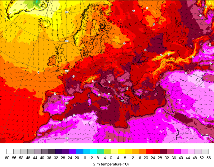
It is thought that Europe is currently experiencing the peak of this heatwave, with parts of Greece, eastern Spain, Sardinia, Sicily and southern Italy seeing temperatures above 45°C at the start of this week.
Contributing factors – high pressure and warm air transport
“The current extreme heat is due mainly to a slow-moving anticyclone, a high-pressure system, that is dominating the upper atmosphere over southern Europe,” explained Florian Pappenberger, Director of Forecasts at ECMWF. “Anticyclones cause subsidence, or downward motion of air. As the air mass moves down it is compressed and thus warmed.”
Such high-pressure systems are also associated with reduced cloud cover, allowing more solar radiation to reach the ground. This in turn allows for substantial heating of Earth’s surface by the sun, heat which then moves upwards into the atmosphere. The long days and short nights of summer mean that this heating effect is maximised.
Advection, that is broadscale winds blowing in this case hot air from one place to another, for example from northern Africa into Europe, can also contribute to heatwaves. For the current heatwave that seems to be less important, but in other cases it can be the main factor.
Atmospheric dynamics are complex, with interactions between the waxing and waning of anticyclones and advection. This is one factor that makes weather forecasting challenging.
Atlantic Ocean heatwave
Another possible influence on Europe’s current weather is the Atlantic Ocean heatwave that was reported on in early July. During June, and into the start of July, the Atlantic Ocean has been warmer than average across most of its basins, especially near North America and Europe. While atmospheric circulation can affect the ocean, the opposite is also true. For example, ocean heatwaves can affect atmospheric circulation patterns and can also warm up the airmasses above them. Sea surface temperature anomalies in the eastern North Atlantic have reduced since the exceptional peak in June, but marine heatwaves continue in parts of the region.
Duration and relief
The current extreme temperatures are expected to last until today or tomorrow (19-20 July), before a slightly less warm air mass moves in from the north. However, this relief may be short lived, as another period of extreme heat is forecast for the end of this week and the beginning of next week (23-25 July).
There are some uncertainties and limitations in predicting such extreme temperatures. For example, some forecast models can underestimate peak temperatures during heatwaves, especially around cities. Another factor that could affect the record-breaking potential is local variability, such as wind direction, cloud cover or terrain features. Therefore, some locations will experience higher or lower temperatures than predicted by models.
Heat domes are only disrupted with a significant change in atmospheric circulation patterns that would displace or weaken the high-pressure system. This could happen due to factors such as large-scale disturbances, for example low pressure systems bringing precipitation, jet stream variability or tropical cyclone activity. However, these factors are hard to predict and depend on many variables.
Heat stress
If the heat dome isn’t disrupted, it is possible that Europe could face more episodes of extreme heat this summer unless a major shift occurs in the general atmospheric circulation.
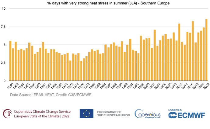
Heat stress is the impact the environment has on the human body, accounting for temperature, humidity, wind speed and other factors. Data for summer 2023 up until 15 July show that large parts of southern Europe have already seen up to 10 days of ‘very strong heat stress’, and parts of southern Spain have experienced up to 30 days of ‘very strong heat stress’. Last year, southern Spain saw 50-60 days of very strong heat stress, and in some small areas, up to 70 days, over the whole summer. This region has already seen some days with ‘extreme heat stress’ so far this summer, and it is likely that the data will show that parts of southern Europe experienced ‘extreme heat stress’ during the most recent heatwave.
“In the longer term, as the climate warms, Europe is seeing an increasing number of summer days with ‘very strong heat stress', and in southern Europe, an increasing number of days with ‘extreme heat stress’. A recent study in Nature Medicine indicated that more than 60,000 people in Europe lost their lives due to the extreme heatwaves last summer,” explained Carlo Buontempo, Director of the Copernicus Climate Change Service (C3S).

Figure 1: Percentage of days during summer with ‘very strong heat stress’ (UTCI between 38 and 46°C) in southern Europe, from 1950 to 2022. Data source: ERA5-HEAT. Credit C3S/ECMWF.
Wildfires
As well as affecting health, weather conditions have an impact on the likelihood of wildfires. During this heatwave, such conditions have mostly affected the Iberian Peninsula, Northern Morocco, and Algeria. There have been high nighttime temperatures in these regions, remaining above 22°C for most nights during this heatwave. Low relative humidity, with values below 20-10% in parts of southwestern Europe, has allowed for poor moisture recovery overnight.
The Fire Weather Index (FWI) is a meteorologically based index used worldwide to estimate fire danger. Values have been around 80, classified as ‘very extreme’ by the Copernicus Emergency Management Service. In the Canary Islands, on Friday 14 July, extreme fire weather was predicted due to a combination of extreme landscape flammability and strong winds. On Saturday 15 July, thousands of residents were evacuated as a wildfire ignited in La Palma. The fire has already burned more than 5,000 hectares.
“Weather conditions remain conducive to wildfires for the whole of the upcoming week in most parts of Spain and the Mediterranean islands, especially Sardinia, but conditions should ease from 22 July,” said Francesca Di Giuseppe, Fire Forecast Coordinator at ECMWF.
While the current heatwave is expected to last until around 26 July, another period of extreme temperatures may follow if the heat dome persists. C3S seasonal forecasts also predict that well-above-average temperatures are likely to continue across Europe until the end of summer, with the exception of southeastern parts of the continent where large uncertainty leaves the probability for extreme conditions close to average.
“C3S is monitoring the evolution of the season. June was the warmest on record for the globe as a whole, and the first 15 days of July have been the warmest 15 days on record. This means that the chance of having a record-breaking summer for the globe is not remote," concludes Carlo Buontempo.
ECMWF forecasts are updated four times a day and the latest can be found through our open charts website.
Banner image

This chart in the top banner is from ECMWF’s publicly available catalogue and it shows 2-metre temperature and 30-metre wind for 18 July 2023 at 12 UTC.
