

ECMWF news highlights in 2021 include two upgrades of our Integrated Forecasting System that improved forecasts; projects and workshops to drive forward weather science; and new developments regarding the EU-funded Copernicus services implemented by ECMWF.
Better forecasts
An upgrade of ECMWF’s Integrated Forecasting System (IFS) to Cycle 47r2 implemented on 11 May introduced single precision for high-resolution and ensemble forecasts (HRES and ENS) and increased the vertical ensemble resolution.

Eight-day tracks of Hurricane Laura from 12 UTC on 22 August 2020 in high-resolution deterministic forecasts with double precision (red) and single precision (blue) along with those from the operational ensemble at the time.
The increase in vertical resolution from 91 to 137 levels was applied to all ENS forecasts in the medium to the extended range.
Another upgrade to IFS Cycle 47r3 implemented on 12 October improved the representation of moist physics in the model and increased satellite observation usage in cloudy regions in data assimilation.
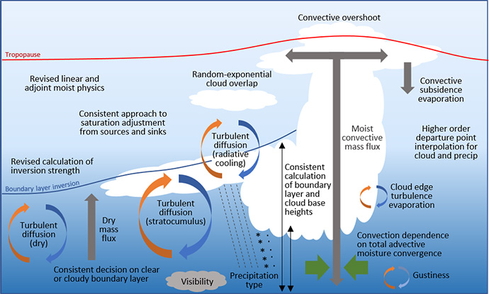
This illustration highlights many of the turbulence, cloud and convection processes that were modified in the moist physics upgrade in IFS Cycle 47r3.
ECMWF users were updated on the first upgrade and more during the Using ECMWF’s Forecasts event (UEF2021) from 1 to 4 June 2021. The meeting, held virtually because of COVID-19, attracted people from all over the world to discuss and provide feedback on ECMWF products and services.

The theme of UEF2021 was ‘Weather in extraordinary circumstances’.
Driving forward weather science
In January 2021, we launched ECMWF’s Strategy 2021–2030, which will guide our activities over the next ten years. The emphasis is on providing ever more skilful forecasts to our Member and Co-operating States and users around the world.

Image: © Nastco/iStock/Getty Images Plus
On 5 March, ECMWF presented EU plans to develop a high-precision digital model of our planet. The initiative is called Destination Earth (DestinE). Its purpose is to create digital twins of the Earth that will make it possible to interactively explore various natural processes and human activities.

ECMWF is to ingest data from Saildrone uncrewed surface vehicles (USVs) to improve our understanding of the behaviour of the Gulf Stream and its influence on weather.
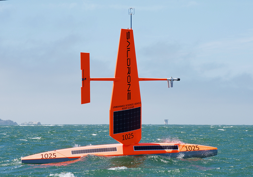
Saildrone USVs carry a wide range of sensors measuring meteorological, oceanic and environmental parameters. (Photo: Saildrone, Inc.)
ECMWF needs up-to-date satellite observations of weather-related variables. EUMETSAT will launch geostationary and polar-orbiting satellites over the next few years that provide some innovative capabilities, including the first infrared soundings from geostationary orbit.

EUMETSAT is to launch new geostationary and polar-orbiting satellites over the next few years. (Images: ©EUMETSAT)
ECMWF held a biennial event on the use of high-performance computing in meteorology from 20 to 24 September, bringing together experts from national weather centres, academia and industry.

And in November, EUMETSAT started to decommission the Metop-A satellite, which had brought tremendous benefits to numerical weather prediction (NWP) after its launch 15 years ago.

ECMWF’s Copernicus services
ECMWF has signed an agreement with the European Commission to continue implementing the EU-funded Copernicus Climate Change Service (C3S) and Copernicus Atmosphere Monitoring Service (CAMS) for the next seven years.

ECMWF will also continue as the computational centre for the hydrological forecasting activities of the EU-funded Copernicus Emergency Management Service (CEMS) until 2027.

The disastrous flood which hit several European countries in July 2021 illustrates the importance of EFAS as a critical European tool to forecast flooding events. (Photo of Erfstadt-Blessem, Germany – credit: Rhein-Erft-Kreis)
In April, the EU-funded Copernicus Climate Change Service (C3S) implemented by ECMWF produced a comprehensive overview of last year’s European climate.

Surface air temperature for 2020, shown relative to the 1981–2010 average. Data source: ERA5 reanalysis. Credit: C3S/ECMWF.
And a European programme to build a monitoring and verification support capability for global emissions of carbon dioxide (CO2) related to human activities entered a new phase in January. The ECMWF-coordinated Copernicus CO2 (CoCO2) project to build a prototype system by the end of 2023 held its first General Assembly from 16 to 18 November.

The CO2 monitoring capability will be supported by up to three satellites (Image copyright: OHB).
The future European support capability will be part of the EU-funded Copernicus Atmosphere Monitoring Service (CAMS) operated by ECMWF.
ECMWF becomes a multi-site organisation

ECMWF officially became a multi-site organisation, with the opening ceremonies for offices in Bonn, Germany, and its data centre in Bologna, Italy, on 13 and 14 September 2021, respectively.
The focus in Bonn is on work conducted in partnership with the EU, including the Copernicus Earth observation programme and the planned Destination Earth initiative.
Other news
More reports can be found on the News page of the ECMWF website.