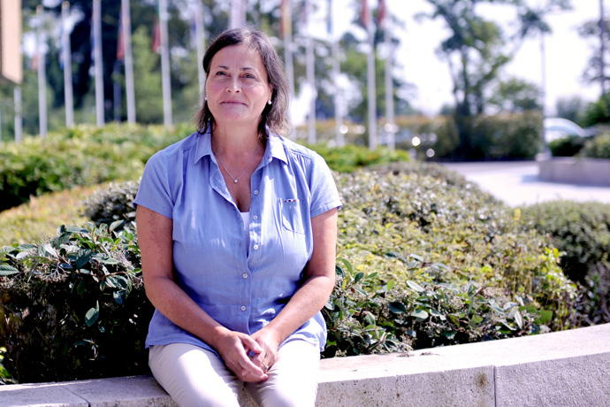

Laura Ferranti joined ECMWF in the mid-eighties and has worked on sub-seasonal to seasonal predictions ever since.
ECMWF’s Annual Seminar from 2 to 5 September 2019 focuses on recent progress and future prospects in sub-seasonal and seasonal forecasting. Laura Ferranti, one of the organisers of this flagship event in ECMWF’s calendar, has decades of experience in the field.
After completing a degree course in physics in Italy, Laura joined ECMWF in the mid-eighties to study atmospheric predictability on long timescales. During this period, she completed her PhD at the University of Reading.
At the time, ECMWF was exploring the feasibility of forecasts beyond the medium range (10 days). Skilful weather predictions were still limited to a few days ahead and it was by no means certain that sub-seasonal forecasts could have useful skill.
“The focus of my work was to study the impact of conditions in the tropics on the extratropics,” Laura recalls.
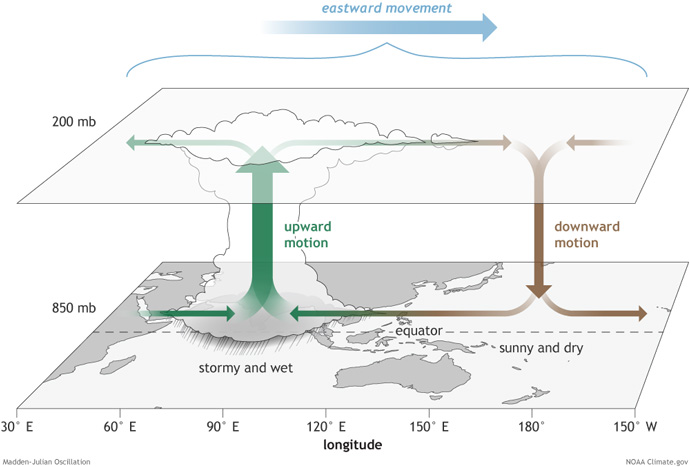
“We produced one of the first studies to demonstrate that the Madden–Julian Oscillation (MJO), a travelling pulse of cloud and rainfall near the equator, is a source of predictability for the extratropics.”

An MJO starts with enhanced convection and rainfall developing over the western Indian Ocean. This moves slowly eastwards as a pulse of wet and windy weather of varying amplitude circling the globe. Each cycle lasts about 30 to 60 days. In the diagram, horizontal arrows pointing left represent easterly wind departures from average winds, and arrows pointing right represent westerly wind departures from average winds. (Source: NOAA Climate.gov/Fiona Martin)
Subsequently Laura moved into the field of diagnostics and forecast product development. Her Annual Seminar talk will give an update on efforts to develop products that can help to predict cold spells and heatwaves in Europe more than two weeks ahead.
The goal at these timescales is not to predict specific weather conditions but to predict deviations from normal conditions averaged over certain regions and periods of time.
Recent progress
Seasonal forecasts (more than two months ahead) began to be produced operationally at ECMWF from the late nineties, while sub-seasonal forecasts only followed in 2004. There is a reason for the gap.
It had long been understood that large-scale and slowly changing conditions in the ocean, such as the El Niño Southern Oscillation (ENSO) in the equatorial Pacific, are a source of predictability at the seasonal timescale.

ECMWF’s seasonal forecasts of the 2015/16 El Niño predicted the evolution of this exceptionally strong event well, as shown by these ensemble forecast plumes of monthly mean sea-surface temperature (SST) anomalies in the NINO3.4 region starting on 1 March, 1 August and 1 December 2015. The dashed lines show the observed evolution of SST anomalies. Advance knowledge of El Niño/La Niña conditions, marked by anomalously high/low SSTs in the equatorial Pacific, is an important driver of predictability for seasonal forecasts.
It was less clear what could serve as sources of predictability at the sub-seasonal timescale. Since the early 2000s, however, things have moved on.
“We are now better able to exploit the predicted evolution of the MJO, conditions in the stratosphere and other factors to enable skilful sub-seasonal forecasts,” says Laura.
“A lot of progress has been made as part of the WMO’s Sub-seasonal to Seasonal (S2S) Prediction Project; more and more institutions have begun to produce S2S forecasts operationally; and demand from users interested in seamless predictions from minutes to months ahead is growing.”
Predicting weather regime changes
A particular concern at the sub-seasonal range is the ability to predict high-impact, large-scale and long-lived weather events, such as cold spells or heatwaves.
ECMWF’s Strategy to 2025 calls for skilful predictions of regime transitions up to four weeks ahead.
“That’s an ambitious goal, but we are making progress,” says Laura. “Tests have shown that an experimental product to predict cold spells in Europe has useful skill up to two and a half weeks ahead.”
The product exploits the fact that cold spells in different parts of Europe are closely linked with the occurrence of particular weather regimes. These include a blocking high over Scandinavia (‘Blocking’ in the Figure below), and anomalously high pressure over Greenland combined with low pressure over the Azores (a pattern known as the negative phase of the North Atlantic Oscillation, ‘NAO-‘).
The occurrence of cold spells in Europe is closely linked to large-scale atmospheric circulation patterns, such as Blocking and the negative phase of the North Atlantic Oscillation (NAO-). In the figure, this is illustrated for nine different regions in Europe. For each region, the diagrams show the dominant circulation patterns associated with severe cold events (indicated by the dots) that occurred from 1980 to 2015. For more details, see the recent ECMWF Newsletter article on ‘A new product to flag up the risk of cold spells in Europe weeks ahead’.
Work on a similar product for heatwaves is under way. “We expect the skill in predicting heatwaves to be a little lower since weather regimes tend to be less predictable in summer,” Laura says.
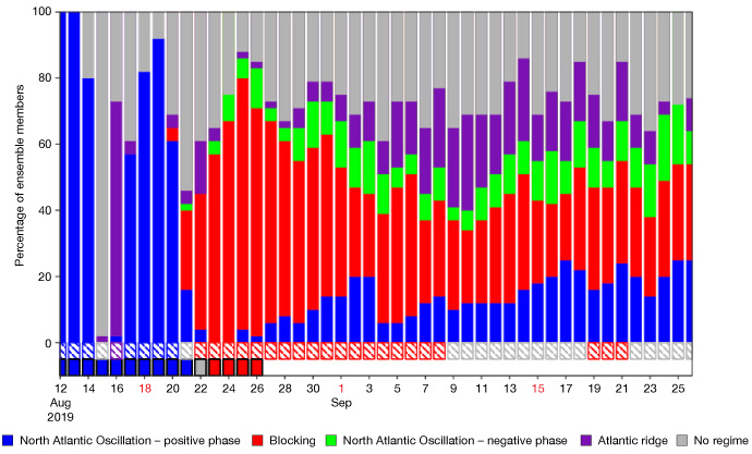
Nevertheless, skilful predictions of weather regimes beyond the medium range in summer are possible, as illustrated by the test product weather regime forecast shown below.

The chart shows the percentage of ensemble forecast members that predict different types of weather regimes for the European domain. In this case, the forecast starting on 12 August 2019 predicted a growing probability for a ‘blocking’ weather regime from 21 August, which in fact came to pass on 23 August and was still in place on 26 August, according to the verification shown in the small columns at the bottom of the chart. The hatched bars represent the ensemble mean regime attribution.
Flow-dependent verification
Laura has also been working on flow-dependent assessments of forecast skill.
The basic idea is simple: the skilfulness of sub-seasonal forecasts depends on the presence of Earth system signals at larger spatial and temporal scales than the ‘weather noise’.
“El Niño and La Niña events, active periods of the MJO, stratospheric polar vortex disruptions, the occurrence of certain large-scale atmospheric regimes, and persistent anomalies in the ocean or the land surface provide strategic windows of opportunity for skilful forecasts,” Laura says.
Flow-dependent verification aims to assess how much these different drivers of predictability influence forecast skill.
“The results can give users a better sense of how skilful forecasts may be at different times. They can also tell modellers where they could usefully focus their efforts to increase forecast skill further. There is some scope yet to increase the skill of sub-seasonal forecasts.”

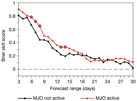
The skill of extratropical sub-seasonal forecasts tends to be higher during active MJO events, as illustrated here for predictions of NAO- weather regimes. Higher values mean a better skill score. Larger symbols with black outlines indicate the forecast ranges where the scores are statistically different at the 90% confidence level. For more details on these results, see the article by Ferranti et al. in the Quarterly Journal of the Royal Meteorological Society (2018), doi: https://doi.org/10.1002/qj.3341.
