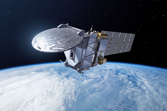

The EarthCARE satellite will provide cloud data to be assimilated at ECMWF. (Image: ESA–P. Carril)
Recent work has prepared the ground for ECMWF to assimilate satellite observations providing information on the vertical structure of clouds.
Assimilating such observations has never been attempted before. It will help to determine the initial conditions on which global weather forecasts are based. This will in turn improve the forecasts.
The joint European/Japanese EarthCARE satellite to be launched in 2021 as part of ESA’s Living Planet Programme is expected to provide the cloud data to be assimilated.
EarthCARE data will also help to reduce forecast errors by supporting weather model development.
Preparing the ground
Previous studies have shown that cloud radar and lidar measurements have the potential to improve weather forecasts if they are assimilated into global numerical weather prediction models.

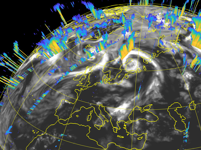
Radar and lidar satellite observations provide a wealth of information on the vertical structure of clouds, which can help to determine the initial conditions on which weather forecasts are based.
A wide range of preparatory work to make such assimilation possible has recently been carried out at ECMWF, partly funded by ESA.
It includes developing and then optimising the ‘observation operator’, which transforms cloud-related model data into simulated satellite data.
Such a transformation is necessary to be able to compare model output with satellite observations.
“Satellite observations of the vertical structure of clouds come in the form of radar reflectivity and lidar backscatter data,” says ECMWF scientist Marta Janisková.
“Using information given by these observations, model variables such as temperature and in-cloud water content can be adjusted to more realistic values, thus improving weather forecasts.”

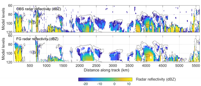
The plots show observed radar reflectivity (top) and radar reflectivity from a short-range forecast (first guess - FG) using the new observation operator (bottom) covering a portion of orbital track at about 2100 UTC on 31 July 2007. Data assimilation aims to bring the short-range forecast more in line with the observed values. The observations are from the CloudSat satellite.
A new bias correction scheme also had to be developed.
“Systematic deviations between cloud satellite data and their model equivalents point to bias in the model or the observations, which must be removed to make the data usable,” says ECMWF scientist Mark Fielding.
“Differences tend to arise from assumptions of cloud-ice particle shape or the way clouds overlap.”
In addition, an automated monitoring system for cloud radar and lidar data has been set up. This will be used to monitor the data to make sure the observations and the model behave as expected.
The monitoring system will also enable satellite data anomalies to be detected quickly and fed back to ESA.
Better forecasts
A series of experiments have been run to test the impact of assimilating cloud radar reflectivity and lidar backscatter data on forecasts.
They show that assimilating the data moves the conditions used to initialise forecasts closer to observations. This is especially true for wind.
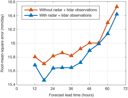
Assimilating the data also reduces forecast errors, particularly for temperature, wind and precipitation.
The size of the improvements varies with geographic location. For precipitation, it is greatest in the tropics.

The plot shows 12-hour moving-average root-mean-square error for forecasts of near-surface rain rates in the tropics (30°N to 30°S) initialised at 00 UTC and 12 UTC compared to independent observations (TRMM radar measurements) for the period 1 August 2007 to 10 August 2007. It shows that the errors are smaller when cloud radar and lidar satellite observations are assimilated.
From CloudSat and CALIPSO to EarthCARE
Cloud profile data can help to improve forecasts in other ways. They can, for example, support weather model development by helping to understand cloud-scale processes and the formation of storms.
Data from NASA’s CloudSat satellite and NASA/CNES’s CALIPSO satellite have already proved extremely valuable in this regard, and data from the EarthCARE satellite is expected to boost model development further.
The CloudSat and CALIPSO satellites were both launched in 2006 and are nearing the end of their lifetime. They have provided the data used in the data assimilation experiments described here.
The real-time data to be assimilated at ECMWF will come from the EarthCARE satellite to be launched in 2021.
The EarthCARE mission will use high-performance radar and lidar instruments never deployed in space before.
The Atmospheric Lidar (ATLID) will provide vertical profiles of aerosols and thin clouds, and the Cloud Profiling Radar (CPR) will provide vertical profiles of clouds, including thicker clouds.
Further information
More information about the work on cloud profile data assimilation carried out at ECMWF can be found in a summary report by Marta Janisková and Mark Fielding available on ECMWF’s website.
