

Exceptionally intense rainfalls from 13th May onwards following weeks of wet conditions led to disastrous and wide spread flooding in the Balkans, in particular Bosnia-Herzegovina and Serbia. Critical flooding was also reported in other countries including Southern Poland, Slovakia, and the Czech Republic. The events in Bosnia-Herzegovina and Serbia are reported to be the worst since more than 100 years. 44 casualties have been reported so far for both countries, also one person died due to the floods in Croatia and in the Czech Republic. More than a million inhabitants are estimated to be affected by this flood event. Both Bosnia-Herzegovina and Serbia activated the EU Community Mechanism for help in the afternoon of the 15th May and again on the 17th for further assistance for Bosnia-Herzegovina.
|
|
EFAS interface showing all EFAS notifications to national authorities based on 12:00 forecasts from the 12th May. |
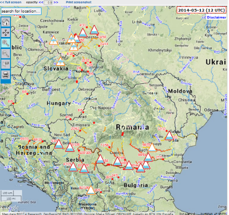
The JRC contributes to European emergency preparedness with actions before and during the crisis. The European Flood Awareness System (EFAS) was developed by the IES and other research institutes to provide European overviews of ongoing and upcoming floods to National hydrological services and the European Response Coordination Centre (ERCC) which coordinates international aid on EU level. EFAS, now part of the Copernicus Emergency Management Service (EMS) and outsourced to Member States, started providing the relevant national authorities and the ERCC with EFAS notifications as early as from the 11th May onwards.
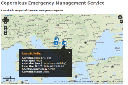
The mapping service of EMS, developed by the IPSC and also an integral part of the Copernicus EMS, has also been outsourced to operations, and provides flood extent maps of the affected areas. It was triggered via the ERCC on the 16th May, first by Bosnia-Herzegovina and then Serbia, followed on 17th by a request from Croatia. Reference maps and flood extent maps delivered by the EMS are available at http://emergency.copernicus.eu
Additionally, as the forecasted events drew nearer and the crisis developed, the expert teams in IPSC and IES provided the ERCC daily with more in-depth information and daily situation reports, integrating scientific information with impact information into products tailored for civil protection, thus contributing to coordinated actions to mitigate potential damages in the countries and across borders.
ECMWF has been involved with EFAS since 2002 with the aim to promote the use of Ensemble forecasts in hydrology in Europe. The European Weather Centre runs EFAS’ computational centre, the heart of data processing and model calculations and hosts the web interface for the Information System.
Background
The European Flood Awareness System
EFAS helps to protect European citizens, the environment, property and cultural heritage when major floods occur. It has been developed and tested at the Joint Research Centre (JRC) of the European Commission, in close collaboration with national hydrological and meteorological services, European civil protection agencies through the Emergency Response and Coordination Centre (ERCC), and other research institutes. It provides pan-European overview maps of flood probabilities up to 15 days in advance, and detailed forecasts at stations where the national services are providing real-time data. More than 30 hydrological services and civil protection services in Europe are part of the EFAS network.
Aims:
- Added-value early flood forecasting products for hydrological services
- Unique overviews of current and forecast floods in Europe more than 3 days in advance
- A European network of operational hydrological services
Co-ordination
Since 2011, EFAS has been part of the Copernicus Emergency Management Service (EMS). Several centres, run by European organisations, are responsible for producing and providing the flood information:
- EFAS Hydrological data collection centre - REDIAM and ELIMCO - Collects historic and real-time discharge and water-level data
- EFAS Meteorological data collection centre - outsourced, but running on site of JRC Ispra, Collects historic and real-time meteorological data
- EFAS Computational centre - European Centre for Medium-Range Weather Forecasts, Responsible for running the forecasts, post-processing, and hosting the EFAS information system platform
- EFAS Dissemination centre - Swedish Meteorological and Hydrological Institute, Slovak, Hydrometeorological Institute and Rijkswaterstaat (the Netherlands), Analyses the results daily, assesses the situation, and sends information to the EFAS partners
The European Commission is responsible for contract management. The JRC supports EFAS through research and development
Further information