

ECMWF is one of 127 participating organisations which, together with 105 member nations and the European Union, form the Group on Earth Observations (GEO).
Earth observations are data and information collected about our planet: atmospheric, oceanic or terrestrial. This includes space-based or remotely sensed data, as well as ground-based or in situ data. Such data are becoming ever more important to understand, monitor and manage the risks from a changing global environment. They are essential to ECMWF too.
GEO plays a vital role in advancing the availability of long-term, global data and modelling information as a basis for sound decision making. The GEO community focuses on three global priority engagement areas: the United Nations (UN) 2030 Agenda for Sustainable Development, the Paris Agreement of the UN Framework Convention on Climate Change, and the Sendai Framework for Disaster Risk Reduction.
GEO’s role in consolidating observing networks is paramount to our community. Weather forecasts rely on Earth observations – at ECMWF, we process and use around 40 million observations every day from all over the world. Our goals of improving Earth system modelling and data assimilation to enable better weather forecasts will require more observations of the atmosphere, oceans and land surfaces. GEO’s work helps to improve global coverage and to make consistent and complete datasets available.
Florence Rabier, ECMWF Director-General
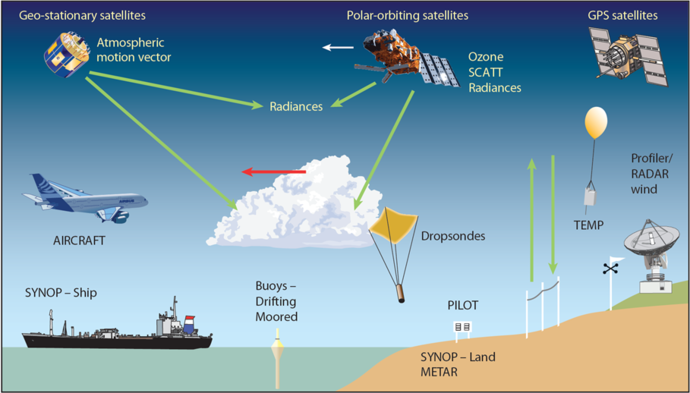
ECMWF’s weather forecasts depend on observations of the atmosphere, land and oceans.
The GEO community is creating a Global Earth Observation System of Systems (GEOSS) to better integrate observing systems and share data by connecting existing infrastructures using common standards. There are more than 400 million open data resources in GEOSS from over 150 national and regional providers. ECMWF is one of them; others include NASA, ESA, the WMO and various commercial organisations.
ECMWF contributes to GEO in several ways: it provides environmental information services through its involvement in the EU Copernicus programme; it makes available global analyses and predictions from open access databases; and it carries out research on the utilisation of Earth observations for ensemble weather analysis and prediction.
On his return from the 2018 GEO Plenary, Jean-Noël Thépaut, Head of the Copernicus Climate Change Service (C3S) at ECMWF, commented:
The GEO week in Kyoto was eventful for ECMWF. We gave presentations in two side events: ‘Translating the Paris Agreement into observational needs’ and ‘In-situ observations by European Research Infrastructures for Sustainable Development: The ENVRI approach’. These two well-attended events allowed us to present our two services CAMS and C3S, how they rely on the infrastructures and knowledge of ECMWF and its Member States, and how we envisage playing an important role in the future in the building of an anthropogenic CO2 emissions monitoring system.
The GEO plenary was also interesting, with the new Secretariat Director Gilberto Câmara stressing the role of GEO as an information technology enabler, fully embracing the rapid evolution of the Earth observation market and new digital economy. The C3S Climate Data Store was even compared to a European Google for climate information!”
Providing environmental data to GEO through the EU Copernicus programme
The European Earth observation programme – Copernicus – represents the European Commission’s main contribution to GEO. ECMWF, as the operator of the Copernicus Atmosphere Monitoring Service (CAMS) and Climate Change Service (C3S), has become a major provider of environmental data to the GEO community. Data include ECMWF reanalyses (such as ERA5) and climate forecasts which are available through the C3S Climate Data Store. Air quality, fire monitoring and stratospheric ozone data are provided through CAMS.
ECMWF contributes to the Copernicus Emergency Management Service through its involvement in the European and Global Flood Awareness Systems (EFAS and GloFAS) and the Fire prediction system. ECMWF also supports the AIP8-GEOSS Water Services and GEO Global Water Sustainability (GEOGLOWS) initiatives, which encourage and help government data providers and research centres to publish water resource time series data. These data are important to our understanding of the frequency, variability and consequences of extreme weather events (such as storms, floods and drought). During the GEO plenary, the GEOGLOWS initiative, and in particular the role of ECMWF in the GloFAS initiative, was praised as an example of a very high quality and highly relevant service for society.

An example of data provided through the Copernicus Climate Change Service. Daily mean surface air temperature in Europe in July 2010 from the most recent ECMWF reanalysis (ERA5). ERA5 provides data on many atmospheric, land-surface and ocean parameters and is available through the Copernicus Climate Data Store. The entire ERA5 dataset from 1950 to present is expected to be available for use by early 2019.
Providing access to global analyses and predictions
The International Grand Global Ensemble (TIGGE) database consists of ensembles of forecast data from ten global NWP centres available via data archive portals at ECMWF and CMA. TIGGE-LAM extends the TIGGE archive with weather forecasts from limited-area model ensembles run at horizontal resolutions from 12 to 2 km. Output from eight limited-area models is being ingested in the archive each day.
TIGGE has become a focal point for a range of research projects, including research on ensemble forecasting, predictability and the development of products to improve the prediction of severe weather. TIGGE-LAM provides insight into the benefits of high-resolution models.
ECMWF created and maintains the archive for the S2S (sub-seasonal to seasonal) prediction project, which aims to improve forecast skill and promote uptake by operational centres and the applications community. The archive is an extensive database of sub-seasonal (up to 60 days) forecasts and re-forecasts (sometimes known as hindcasts) from 11 operational centres.
TIGGE, TIGGE-LAM and S2S form part of the weather contribution to the Global Earth Observation System-of-Systems (GEOSS) and are accessible through the GEOSS Common Infrastructure (GCI).
The growing importance of Earth system data
ECMWF’s Strategy 2016–2025 calls for improved Earth system modelling and data assimilation to enable better weather forecasts. This will require more observations of the atmosphere, ocean, land, rivers and lakes, atmospheric composition and sea ice. The associated observation requirements will become more demanding over time as the models’ realism improves. Continued progress towards improved weather forecasts thus depends on sustained investment in the capabilities to observe the Earth system and ECMWF involvement in groups like GEO will only become more important in the future.