Climate change and consequent changes in weather patterns are among the greatest environmental challenges of the 21st century. The implications of a warming climate are widespread, affecting fresh water resources, global food production and sea levels.
The need for systematic observations of climate over a significant timescale has never been greater than today. To respond to this need, in 2012 the European Space Agency (ESA) launched the Climate Change Initiative (CCI) programme, which is currently in its third phase. The objective of CCI is to realise the full potential of the long-term global Earth observation archives that ESA has established over the past 30 years. For more information, see https://climate.esa.int/en/.
At ECMWF, several CCI datasets are used for various applications within our Earth system model. Here we briefly present some examples.
Ocean CCI datasets
Various ocean-related climate data records have been developed during the last two phases of ESA-CCI projects. These include L4 gridded sea-level (SL) anomalies, sea-surface temperature (SST) analysis, sea-surface salinity (SSS) analysis, and sea-ice data (concentration and thickness). These CCI climate data were developed with a focus on reconstructing accurate and homogenous long-term climate signals by using consistent reference satellite instruments throughout the full reprocessing period. As a result, these CCI datasets are commonly used for monitoring and tracking climate change signals related to the ocean. At ECMWF, they have been used for verification of seasonal forecasts and for evaluation of the performance of ocean and sea-ice reanalysis systems. Research activities to investigate direct assimilation of CCI ocean data, such as SST and sea-ice thickness data, in the ECMWF ocean reanalysis system are ongoing as well.
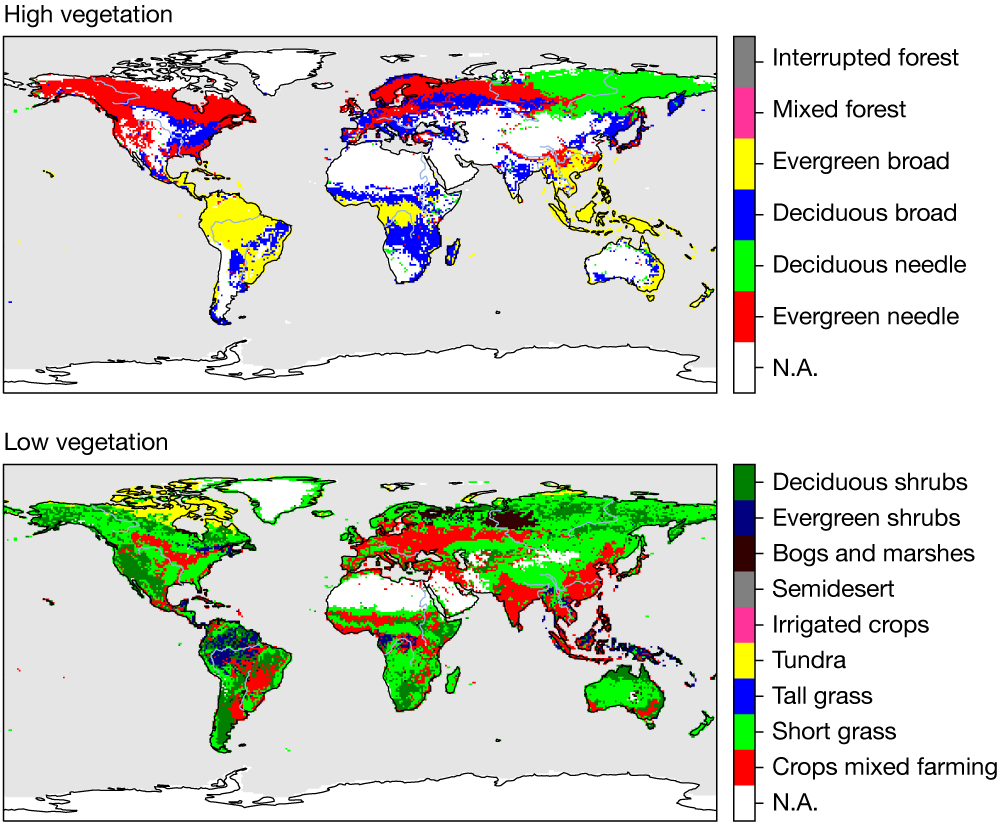
Land CCI datasets
An upgrade to more accurate and up-to-date land use and land cover (LU/LC) maps is being tested within the ECMWF system. This uses a new software framework to generate the model physiography for the ECMWF land surface modelling system (ECLand). The new maps are based on the ESA-CCI LU/LC, which provides consistent maps at 300 m spatial resolution on an annual basis from 1992 to the present. A total of 22 land cover classes are represented, based on the land cover classification system developed by the United Nations Food and Agriculture Organization, and adapted to the Biosphere-Atmosphere Transfer Scheme classes used in ECLand. The introduction of ESA-CCI maps will increase low vegetation and bare ground covers and reduce high vegetation cover. These differences will have a substantial impact on energy, carbon and water fluxes, which are currently being evaluated for future operational implementation.
Snow CCI dataset
ECMWF is part of the Snow CCI Climate Research Group. Preliminary investigations have shown a good level of consistency between the prototype snow cover CCI products and the IMS (Interactive Multisensor snow and ice mapping System) snow cover from the United States National Ice Center that is currently assimilated at ECMWF for numerical weather prediction and reanalysis. However, IMS high-resolution snow cover is available from 2004 only. This results in a discontinuity in snow cover and snow mass in ECMWF’s ERA5 reanalysis in 2004. The quality of the CCI snow cover product from the early 1980s opens up possibilities to investigate CCI snow cover product assimilation in ECMWF’s Integrated Forecasting System for future reanalysis activities.
Fire CCI datasets
It is estimated that about 25%–35% of greenhouse gas emissions result from biomass burning, making the monitoring of fire disturbance a crucial aspect of the climate system. To this end, Fire CCI focuses on the key variable ‘burned area’. It incorporates active fire observations as a supplemental variable to improve detection and reduce latency time, which previously precluded the possibility of using these observations in real time. An ESA-funded study looked at the potential of using Fire CCI to quantify the total fuel released during a fire. It demonstrated that, by directly combining above-ground biomass retrievals and burned areas from Fire CCI, fire emissions improved, leading to a better analysis of aerosol optical depth. Given the impact that biomass burning aerosols have on the energy budget of the planet, this could in turn lead to improved weather forecasts and consequently better skill in downstream applications that rely on it.
Atmosphere CCI datasets
Ozone CCI datasets have been investigated extensively and used in ERA5. Dedicated round-robin assimilation experiments were performed, aiming to identify the best candidates for ERA5. Detailed assessment studies were also performed to evaluate possible synergies of using ozone products derived from instruments with different characteristics. A range of CCI data were also used in the latest reanalysis (EAC4) provided by the EU‑funded Copernicus Atmosphere Monitoring Service (CAMS) run by ECMWF, including O3 products from the SCIAMACHY, MIPAS and GOME‑2 instruments, as well as CO2 and CH4 products from SCIAMACHY and TANSO. More recently, ESA‑CCI Sentinel‑5P ozone data have been used in tests to assess their value for the operational ECMWF numerical weather prediction analysis. These tests have demonstrated a good level of readiness of the data and positive impacts on the fit to other observations. The operational S5P ozone retrieval, produced with an algorithm developed by the German Aerospace Center (DLR), is already used in the global CAMS near-real-time system and the CAMS reanalysis.
Aerosol optical depth (AOD) CCI retrievals from the AATSR sensor on board the Envisat satellite have been successfully assimilated in the CAMS reanalysis. More recently, AOD data from the successor multi-angle instrument SLSTR on board Sentinel‑3 satellites has been investigated in the CAMS configuration. Results of assimilation tests showed that the product had not yet reached the desired maturity level for use in the next CAMS reanalysis. A new version of the retrieval with enhanced features will be released in the next few months.