In the ECMWF Strategy 2021–2030 we aim to move to an ‘all-sky all-surface’ assimilation of satellite observations. Cycle 48r1 of ECMWF’s Integrated Forecasting System (IFS) is planned to go operational in early 2023, and it will include extensive changes to make better ’all-surface’ use of satellite microwave observations.
The upgrades target surface-sensitive microwave channels, for which a lot of data has previously been screened out due to surface types that are harder to simulate. These surface types include land, snow, sea-ice, and mixtures of all surface types. In some channels, the new developments increase the number of observations being assimilated by around 30%, particularly in polar regions and over mixed scenes. The main forecast improvements are in northern high-latitude areas, showing the importance of trying to use more satellite data in these areas.
Main improvements
The Cycle 48r1 developments are just a step in the direction of a complete all-surface assimilation, but they help us preview what we will be working on over the coming decade. For example, in Cycle 48r1 we will be retrieving the sea-ice fraction from microwave observations for the first time in the IFS. It is not yet good enough to be assimilated in the sea-ice analysis, and initially it is intended only for quality control of the microwave observations. But there is clear potential for inferring more surface information directly from satellite radiances in coupled data assimilation.
One component of the package in Cycle 48r1 is the addition of surface-sensitive microwave imager channels over land surfaces. This is a first in global weather forecasting and it depends on having a well-developed ‘all‑sky’ assimilation framework. This is because the main atmospheric information in surface-sensitive channels does not come from temperature or water vapour, but from cloud, rain and snow in the atmosphere. We can now use these observations to help correct forecast errors, such as displaced summertime convection over central Europe. However, the amount of information we can extract is limited by our ability to model the effect of land surfaces on satellite radiances, which is still difficult, particularly in snow-covered areas and deserts. Improvements to radiative transfer modelling for sea‑ice, snow and land surfaces are critical to progressing the all‑sky all-surface strategy.
Another issue that we begin to grapple with in Cycle 48r1 is the treatment of mixed surfaces. These have previously been considered too difficult to assimilate, leading to a loss of data over coastlines, islands and lakes. If we also include mixed ocean/sea-ice surfaces in the figures, then mixed scenes can easily comprise 20% of all microwave radiances, which is a significant loss.
Different surface types have very different effects on the observed radiation, so it is important to know the exact fraction of each surface type in a mixed scene, and to model each surface type appropriately. This makes it more important to know the exact location and shape of the satellite field of view, which can often be much broader than a single IFS grid box. When targeting the atmosphere, it is possible to get away with more approximate treatments. Now that we are hoping to target surface variables, it pushes us to represent the satellite field of view more exactly. All these areas will be important themes of development over the next few years.
More observations in difficult areas
Currently, the all-sky microwave framework is used to assimilate around 17 different sensors and satellites. This includes conical scanners (known as microwave imagers) mainly targeting lower-tropospheric water vapour, cloud and precipitation, and microwave sounders, targeting the humidity or temperature profile, but also sensitive to cloud and precipitation. Together these observations represent around 30% of all observational impact on the short-range forecast.
All these sensors have channels that are sensitive to the surface, but they are only partly utilised or sometimes completely rejected. The impact of the ice-free ocean surface on microwave radiances is relatively well modelled, so coverage over the tropical and midlatitude oceans is mostly complete. By contrast, many observations must be rejected over land and sea-ice areas due to our imperfect physical knowledge of these surface types.
Figure 1 illustrates expected improvements in observational coverage in Cycle 48r1, based on experiments for July 2020. For microwave imager channels like the one shown in Figure 1a,b, observations are added over ice-free polar oceans thanks to new sea-ice retrieval. This enables us to accurately screen out any observations that contain sea-ice, where previously we had to exclude all polar ocean areas as a precaution. Observations are also used over most land surfaces for the first time. This is thanks to a new technique for extrapolating the surface radiative properties across frequencies, based on retrievals at lower frequencies that are less sensitive to cloud and precipitation. It is still too difficult to use observations in this channel over sea-ice, snow, desert or high-altitude surfaces, so there are still some big gaps to fill.
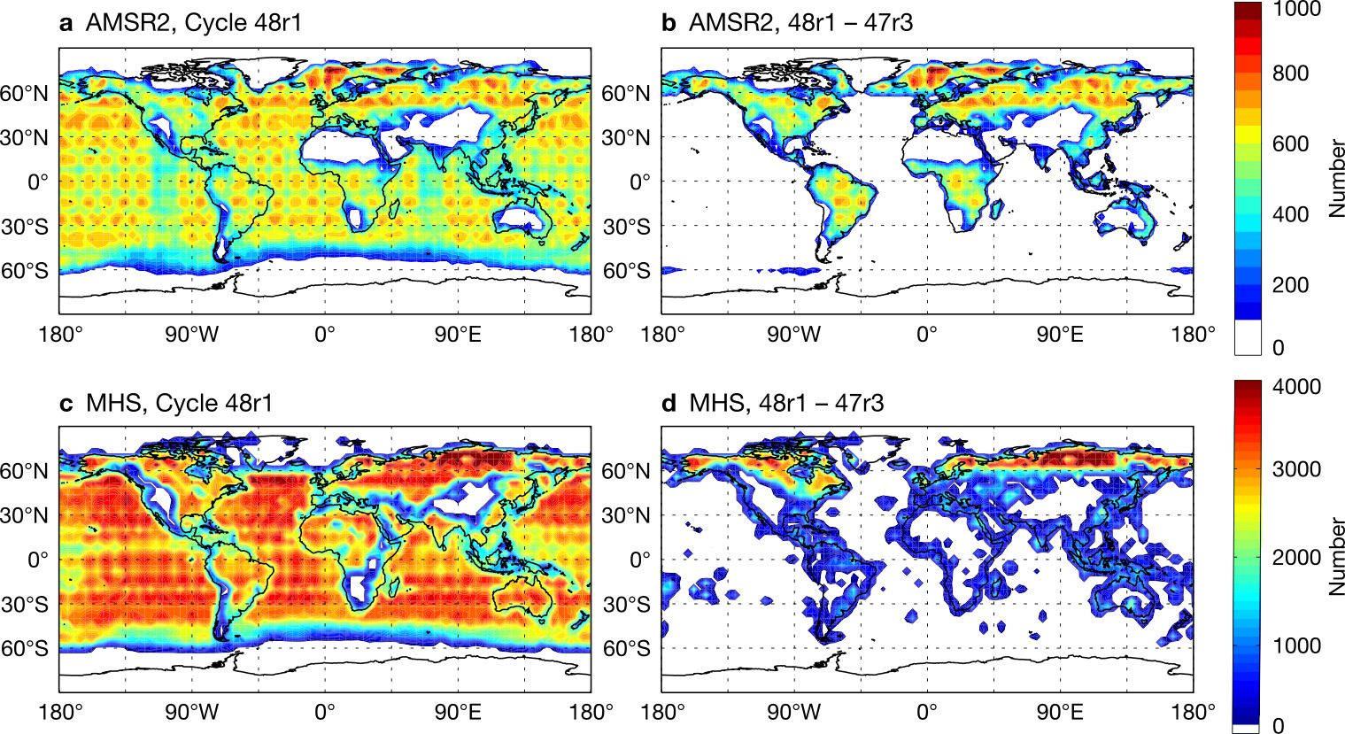
Figure 1c,d shows the new coverage, along with changes, in a microwave humidity sounding channel that has benefited from some of the other components of the 48r1 package. There are more observations over land at high latitudes, thanks to the removal of a quality control check that discarded land observations poleward of 60 degrees. Also evident are more observations around coastlines, islands and lake areas, where the improved treatment of mixed surfaces has also allowed ‘coastal’ scenes to be used for the first time.
Benefits to forecasts
Figure 2 shows the change in wind forecast error coming from the all-sky all-surface upgrade in Cycle 48r1. Blue areas indicate small but often significant improvements in forecasts over high northern latitudes. These results were based on the experiment’s own analysis as the reference, but an observational reference confirms the improved forecasts. For example, background forecasts are around 0.5% better when compared to radiosonde temperature, moisture and wind profiles in Arctic areas (defined as poleward of 60 degrees N, not shown). The recent APPLICATE project has also highlighted the importance of using more satellite observations in polar regions, especially in winter (see Sandu et al., 2021; Lawrence et al., 2019).
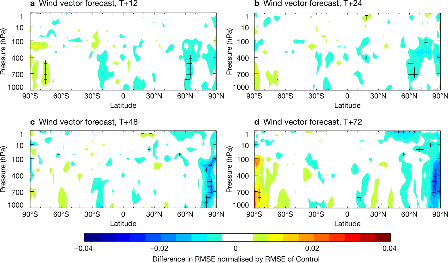
The improvements in Cycle 48r1 likely come from the additional observations over the Arctic Ocean and northern hemisphere land areas, including the many lakes, islands, and coastal scenes that were previously rejected. We were particularly interested to see if the additional microwave imager observations over land were responsible for part of the improvement. As mentioned, these observations are mainly sensitive to cloud and precipitation over land, with less sensitivity to forecast variables such as wind and temperature. But experiments showed that these cloud and precipitation observations probably are contributing to the initial conditions of wind and temperature, too. This would be expected from the generalised tracer effect of 4D‑Var data assimilation, which allows us to infer changes in humidity, winds, temperatures and surface pressure in order to better fit the observations of cloud and precipitation.
Inferring sea-ice fraction from microwave observations
The new sea-ice retrievals to be used in Cycle 48r1 are based on the 10 GHz channels available on some microwave imagers. These low-frequency channels are ideal for inferring the sea-ice fraction because there is a strong contrast in the brightness of the ocean surface and of the sea-ice. These channels have not been used in the IFS before because their atmospheric signal is relatively small. As we move towards all-surface assimilation, low frequency microwave channels are likely to play an increasing role, especially with upcoming sensors like the Copernicus Imaging Microwave Radiometer (CIMR), which will provide observations down to 1.4 GHz.
Figure 3 shows the quality of the initial 10 GHz sea-ice retrievals, compared to the sea-ice fraction that is computed by the OCEAN5 analysis. The overall ice extent is well captured by the new retrievals, but especially in the Arctic in this example, the sea-ice fraction is overestimated. For present purposes this is fine, since the retrieval is only aimed at identifying scenes that are contaminated by sea‑ice for quality control of the atmosphere-targeted microwave observations. The retrievals give an instantaneous view of the sea-ice in the satellite’s field of view, whereas the OCEAN5 analyses are based on observations that are up to 48 hours old. This means that the analysed sea‑ice edge can be in error by up to around 100 km.
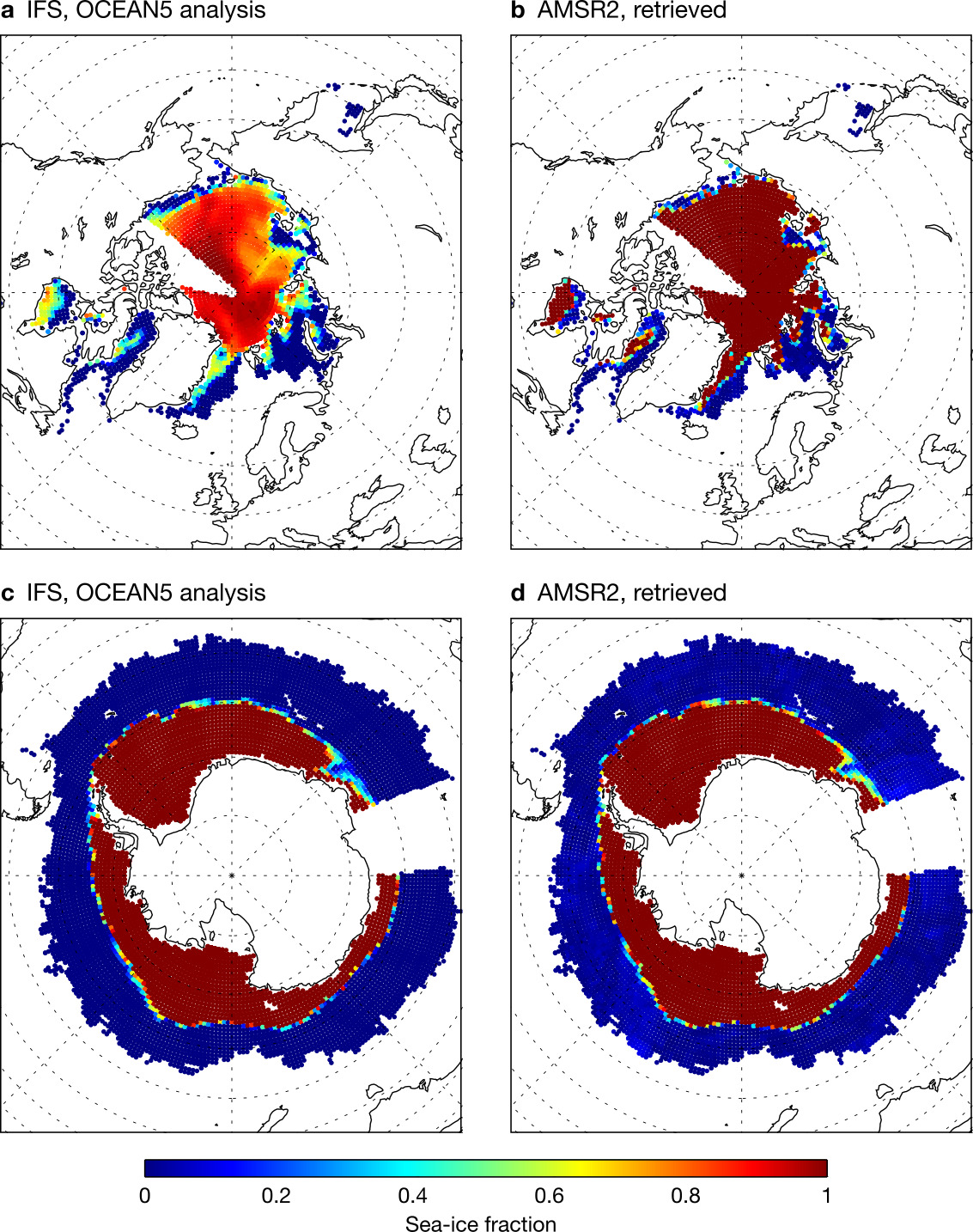
If we can find better ways of modelling the radiative properties of the sea-ice, it will be possible to retrieve a sea-ice fraction that might be accurate enough to try assimilating at ECMWF. There is the possibility of rapid progress in this area, which will be the focus of much work in the coming years.
Radio spectrum challenges
Cycle 48r1 will mark the first time that ECMWF directly assimilates radiances from surface-sensitive channels over land surfaces. These channels occupy small chunks of radio frequency that are protected from other radio emissions, such as 5G mobile telecommunications. However, there is constant pressure on the small amounts of radio spectrum that have been reserved for scientific purposes. Only recently, space agencies and science organisations including ECMWF had to make the case for better protection of 24 GHz observations against unwanted emissions from 5G telecoms applications in neighbouring bands.
We know how much more information we can still extract from microwave observations over land surfaces, but to continue justifying these protected scientific bands, we will need hard evidence of their beneficial impacts on operational environmental forecasts. In some areas, we may be in a ‘use it or lose it’ situation as commercial demands on the radio spectrum continue to increase. Hence, the development of microwave observations faces unique time pressure. As a result, the work in Cycle 48r1 needs to be rapidly followed up, and the push towards all-surface assimilation comes at a very good time.
Outlook
We have already seen the benefit of adding observations of the atmosphere in difficult areas, such as high-latitude land and ocean. However, we expect to see even more benefit by directly exploiting the surface-related information in satellite radiances. This includes information on the sea-ice fraction, soil moisture and snow cover. If assimilated within a coupled modelling framework, better knowledge of these quantities could help improve forecasts well beyond the medium range. As mentioned already, there is still a huge amount of scientific and technical development needed to model the effect of these surfaces on satellite radiances.
Another development in Cycle 48r1 applies to the Advanced Technology Microwave Sounder (ATMS) instrument, which is only assimilated in the clear-sky framework and hence was not covered here. The ATMS development is to treat the surface as a diffuse scatterer, rather than a pure reflector. For future cycles, there is also a possibility to infer the skin temperature from microwave as well as from infrared observations. These are all useful advances but, like the changes documented in this article, they make simplifying assumptions about the surface. Currently we treat the surface as impenetrable to radiation, and possessing a single ‘skin’ temperature. To really move forward in all-surface microwave assimilation, we need more sophisticated modelling.
Rather than forming an impenetrable surface, sea-ice, snow and dry soils are partly transparent to microwave radiation, and the depth of the surface to which the radiation is sensitive depends strongly on the frequency. Hence, in the longer term we need to start including the top few metres of the surface (as well as vegetation) in our physical models of satellite-observed radiation, and representing the scattering, absorption, reflection and refraction of radiation in these materials.
However, a perfect physical model of radiation in the sea-ice, snow or soil layer would require information on the microstructural properties of the surface layers, for example the grain structure of snow or sand. These are often quantities to which satellite data has great sensitivity, but which are not yet represented in our models of the land-surface, snow or sea-ice. This will probably require us to make much more use of a data assimilation strategy known as parameter estimation, to estimate and to keep maps of these microstructural properties from one data assimilation cycle to the next.
We may also need to make increasing use of empirical modelling approaches, particularly machine learning, if the physical models are not good enough. These are all big challenges. Addressing them will be key to implementing the all-sky all-surface strategy over the next decade.
Further reading
Geer, A.J., K. Lonitz, D.I. Duncan & N. Bormann, 2022: Improved surface treatment for all-sky microwave observations. ECMWF Technical Memorandum No. 894.
Lawrence, H., N. Bormann, I. Sandu, J. Day, J. Farnan & P. Bauer, 2019: Use and impact of Arctic observations in the ECMWF Numerical Weather Prediction system. Quarterly Journal of the Royal Meteorological Society, 145(725), 3432–3454.
Lonitz, K., A.J. Geer & N. Bormann, 2022: Towards assimilating microwave imager channels over land. EUMETSAT/ECMWF Fellowship Programme Research Report No. 58.
de Rosnay, P. 2021: Towards consistent exploitation of Earth system observations in coupled assimilation systems, ECMWF Annual Seminar 2021, https://events.ecmwf.int/event/217/timetable/.
Sandu, I., G. Arduini, J. Day, L. Magnusson, H. Lawrence, N. Bormann et al., 2021: How APPLICATE contributed to ECMWF core activities, ECMWF Newsletter No. 168, 24–31.