Philippe Lopez, Senior scientist, Physical Processes Team
The Apollo 11 mission
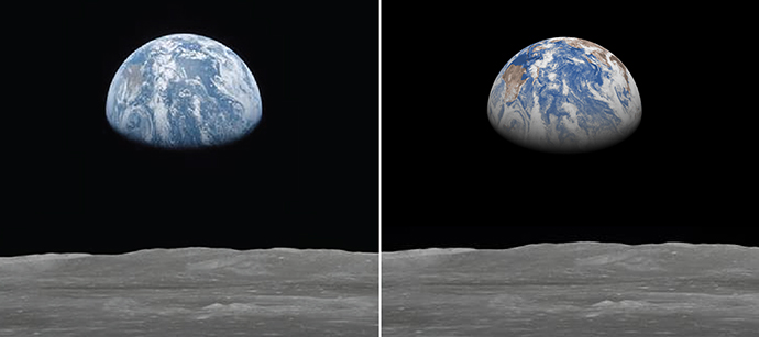
One of the world’s most iconic images is surely the view of planet Earth taken by the Apollo 11 mission on 20 July 1969 as it orbited the Moon, ahead of the first successful Moon landing (below, left).
To celebrate the 50th anniversary of that first Moon landing, I decided to investigate whether a numerical weather forecast obtained with the latest operational ECMWF Integrated Forecasting System (IFS) could reproduce that iconic image.
The weather forecast was initialised on 19 July 1969 at 00h UTC from ECMWF’s ERA-40 reanalysis data and run at 28 km resolution for 29 hours, to match the time and level of detail of the NASA image. ERA-40 was used here because it is currently our best reconstruction of the atmospheric state for 1969. The corresponding pseudo-image “as seen by the model” was then simply computed from the simulated hourly-accumulated solar radiative fluxes at the top of the atmosphere and displayed using a simple program that I wrote for the occasion (below, right).
The comparison displayed below shows that the combination of initial conditions from the reanalysis and a recent version of the ECMWF IFS can simulate cloud patterns (in white) that agree reasonably well with those seen on the NASA image. This is remarkable given the limited number of observations that were used to produce ERA40 reanalyses for 1969 (no satellite data). It is also likely that the use of a more complex visible image simulator would provide an even more realistic image from the model.

NASA Apollo 11 image of the Earth above the Moon taken on 20 July 1969 at around 05h UTC (left) and the corresponding pseudo-image generated from a 29-hour 28-km resolution ECMWF forecast initialised from ERA40 data (right). Both images are centred over the western Pacific Ocean, with the equator running almost vertically and Australia visible on the left in brownish colour.
The Apollo 17 mission
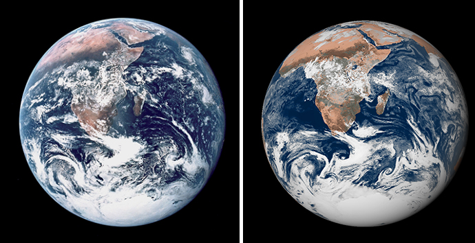
I then turned my attention to the famous “Blue Marble” image taken by the Apollo 17 mission on the way to the Moon on 7 December 1972. This image was compared with an IFS forecast initialised from ERA5, the latest reanalysis produced by ECMWF for the Copernicus Climate Change Service. The forecast was run for 11 hours at ECMWF’s current deterministic forecast resolution of 9 km. Here, this higher forecast resolution was necessary to account for the higher level of detail present in the NASA image compared to the Apollo 11 case.
Again, the simulated and the NASA images exhibit a significant level of agreement in cloud patterns, especially over the Southern Ocean all around Antarctica. Even tropical cyclone Tamil Nadu affecting India (top-right corner) is present in the simulation. Some discrepancies can be identified (over the South Atlantic Ocean, for instance), but this is not surprising given the very limited amount of satellite data used in ERA5 for December 1972.

NASA Apollo 17 image of the Earth taken on 7 December 1972 at 10h39 UTC (left) and the corresponding pseudo-image generated from an 11-hour 9-km resolution ECMWF forecast initialised from ERA5 reanalysis (right).
Although rather realistic, both model forecasts initialised from 1969 and 1972 reanalysis data are clearly not the spitting images of the original NASA pictures. Nowadays millions of additional observations (especially from satellites) are used to improve the initial conditions of our operational weather predictions.
Today…
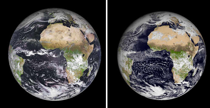
The accuracy of both IFS analyses and forecasts has improved over the years with increasing skill further into the forecast. As an illustration, a recent 84-hour high-resolution 9-km forecast initialised at 00h UTC on 7 February 2019 from ECMWF’s operational analysis is compared with the corresponding visible image from EUMETSAT’s MSG-4 satellite. Even though this is a forecast three and a half days ahead, the pseudo-image from the model agrees quite strikingly with the satellite image, especially in the mid-latitude regions of both hemispheres. Some differences can be found in the tropics, with seemingly too bright (thin) cirrus clouds over parts of the Sahara and an underestimation of the extent of thunderstorm cloud anvils over the equatorial Atlantic Ocean. However, one should keep in mind that some of those differences might disappear with a much more complex visible image simulator.

EUMETSAT’s Meteosat Second Generation (MSG-4) on 10 February 2019 at around 12h UTC (left) and the corresponding pseudo-image generated from an 84-hour 9-km resolution ECMWF forecast initialised from operational analysis (right). The right panel also includes the vegetation cover from the model (in green) to be consistent with the colours used on the satellite image.
Achievements
While NASA’s Apollo missions were the outcome of tremendous technological progress in flight and engineering over several decades, in my view the above simulated images could be considered as a tribute to the worldwide continuous improvements in numerical prediction systems since the 1970s. Today’s systems allow us to not only forecast the weather, but also to produce reanalyses, which possess the amazing ability to open windows into the past.
Credits and sources
I would particularly like to thank my colleagues Margarita Choulga, Simon Lang, Olivier Marsden, Alan Geer, Irina Sandu, Richard Forbes, Hans Hersbach and Adrian Simmons for their technical help or suggestions during this 5-day mini-project. I am also very grateful to both NASA and EUMETSAT for granting access to their images.
