
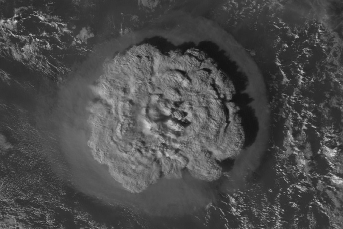
The Hunga Tonga eruption on 15 January 2022 recorded by Japan's Himawari-8 weather satellite. The plume was just under 500 km across. (Source: Japan Meteorological Society, CC BY 4.0)
The eruption of the Hunga Tonga–Hunga Haʻapai volcano in the southern Pacific Ocean on 15 January 2022 had a strong effect on the signals of satellite instruments used by ECMWF. Here we present some of those signals and explain their meaning.
The eruption was so powerful that it could be heard thousands of kilometres away. At the time, signals evaluated by ECMWF showed that the plume rose higher than 20 km. According to recent research, it rose in fact to 58 km, beyond the stratosphere and into the mesosphere.
Aeolus wind satellite
The eruption had a powerful impact on the signals provided by the European Space Agency’s Aeolus satellite. Aeolus is an experimental satellite that provides direct wind profile observations. It works by measuring the backscatter of laser light from air molecules (‘Rayleigh-clear’ data) and from clouds and aerosols (‘Mie-cloudy’ data).
On 15 January, it recorded a large drop in signal in the area of the eruption. This was due to the volcano plume, which must have been present above the top of the Aeolus measuring range, which was set to 20 km high.
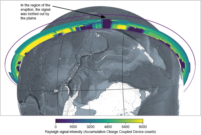
A view of the total attenuation evident in the Aeolus signal. The eruption signal was captured at about 06 UTC on 15 January 2020. This and the following plot were produced using the European Space Agency’s online tool (VirES).
Three days later, the plume was drifting over northern Australia. It had widened considerably by then.
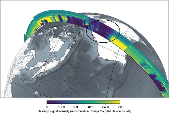
A view of the attenuation of the Aeolus signal over Australia at about 09 UTC on 18 January 2022.
“The Aeolus satellite gave a good indication of the minimum height of the plume and its westward spread over northern Australia and subsequently the Indian Ocean and beyond,” said ECMWF’s Michael Rennie.
On 24 January, Aeolus’ top altitude was raised to 30 km in the tropics to directly capture the volcanic plume. This made it possible to measure Mie-cloudy winds from the strong backscatter, which had spread over the whole tropics by mid-February 2022.
Copernicus observations of sulphur dioxide
The Copernicus Atmosphere Monitoring Service (CAMS), run by ECMWF for the EU, provides information on total column sulphur dioxide (SO2).
This is initialised, in the case of a major volcanic eruption, by the operational assimilation of observations from the Tropomi and GOME-2 satellite instruments.
Several days of total column SO2 observations were assimilated by CAMS following the explosive eruption of the Hunga Tonga–Hunga Haʻapai volcano.
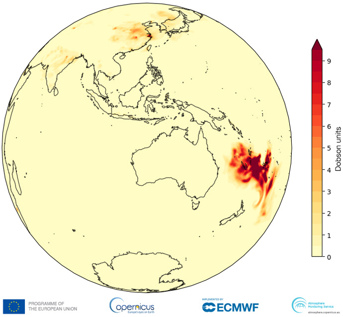
The CAMS analysis of total column SO2 at 00 UTC on 16 January 2022.
“CAMS analyses show initial recirculation of SO2 over the South Pacific before long-range transport across northern Australia to the Indian Ocean, with the leading edge of the plume reaching La Reunion and Madagascar on 22 January,” says ECMWF’s Mark Parrington.
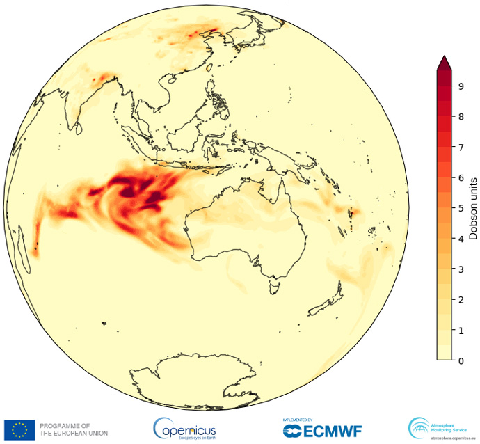
By 22 January, the plume had drifted westwards and dispersed somewhat.
Impact on microwave and infrared satellite observations
For other satellite observations assimilated in ECMWF’s Integrated Forecasting System (IFS), the eruption was most noticeable in stratospheric infrared and microwave channels.
These measurements witnessed a powerful pressure and temperature wave that moved quickly from the ocean surface up into the stratosphere and radiated outward.
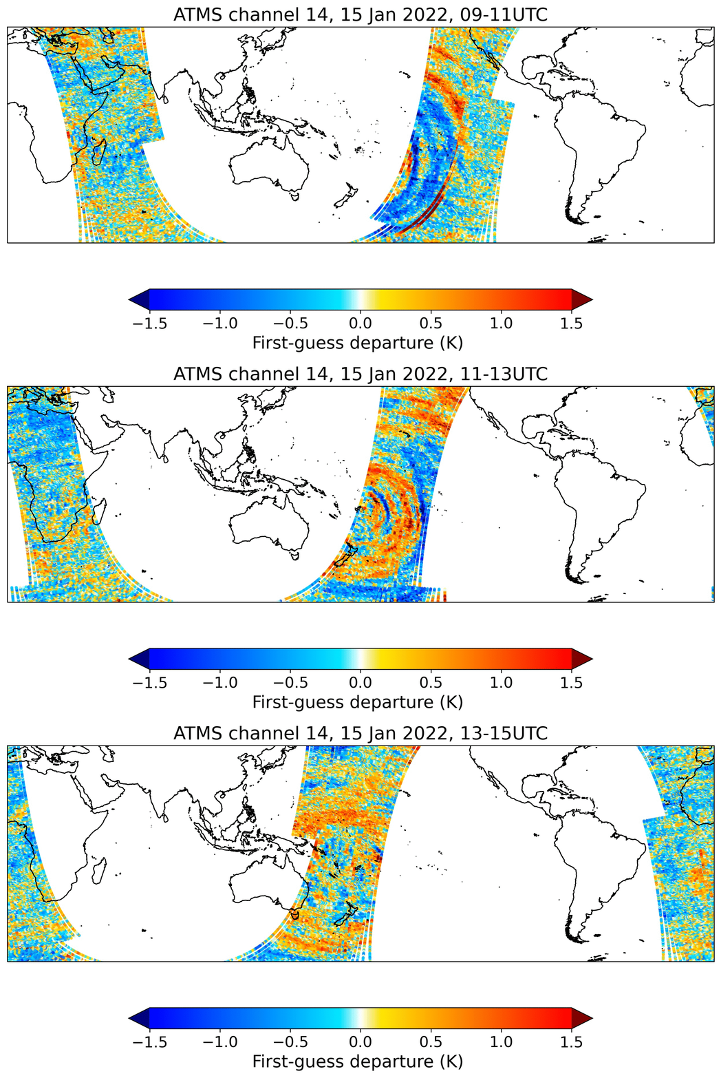
This animation shows first-guess departures (observations minus the model background) from channel 14 of the ATMS microwave sounder in the 5–11 hours after the strongest eruption. The channel has broad sensitivity to temperature in the mid- to upper-stratosphere and peak sensitivity near 5 hPa, corresponding to an altitude of about 36 km.
The combination of well-calibrated satellite observations and a state-of-the-art numerical weather prediction model made the anomalous signals very clear.
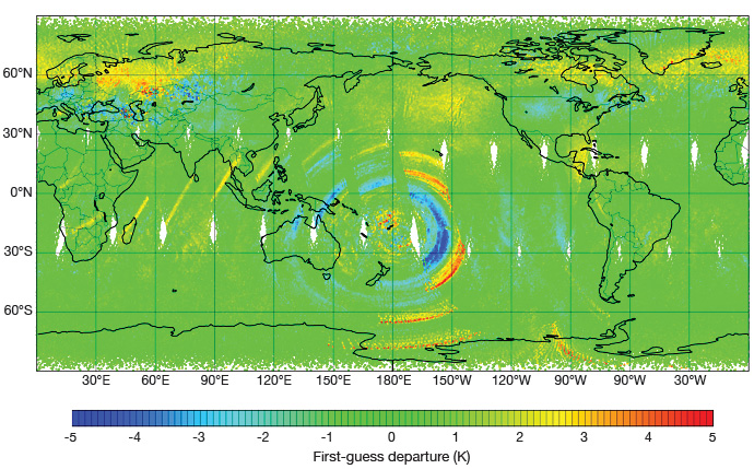
First-guess departures from channel 92 of the IASI infrared interferometer sounder over 24 hours on 15 January 2022.
“The eruption triggered numerous alerts in the ECMWF data monitoring system because the observed radiance characteristics deviated from the expected behaviour,” says ECMWF’s David Duncan. “Effectively all AMSU-A and ATMS stratospheric channels saw alerts in the 12 UTC cycle on 15 January 2022.”
Conclusion
Different impacts of the Hunga Tonga–Hunga Haʻapai volcano eruption were detected by a diverse range of observing systems used by ECMWF and Copernicus.
Some of it was accidental in that the instruments were not built to observe or consider such events. Some of it was intentional, particularly the CAMS observations of SO2 emanating from the eruption.
Together, the satellite images give an idea of the wider repercussions of the eruption on the atmosphere.
