
On the occasion of World Meteorological Day 2022, ECMWF Director of Forecasts Florian Pappenberger looks at how the theme of Early Warning and Early Action ties in with the Centre’s global numerical weather predictions.
One of my favourite ways to start the day is to take an early morning run along the swirling waters and the lush meadows of the River Thames. A few weeks ago, that was made impossible by the extreme winds of storm Eunice. The flagpoles at ECMWF snapped in half, trees across the country toppled, blocking roads, crushing cars, leaving houses without power and sadly killing people. I decided not to venture out into the storm because I had early warnings of the dangerous winds based on excellent forecasts predicting the strength of the storm several days ahead.
This is a clear example of how early forecasts, early warnings, and early actions can work to reduce the risk of loss of life from severe weather.
World Meteorological Day 2022 is dedicated to Early Warning and Early Action, with an emphasis on Hydrometeorological and Climate Information for Disaster Risk Reduction. The World Meteorological Organization (WMO) point outs that forecasts of what the weather will be in the future are not enough. We also need information on the likely impacts of the weather, and the actions we need to take to reduce damage and keep ourselves safe.
Forecasts need to be translated into warnings, and those warnings must lead to actions. At ECMWF, we focus on the first part of this chain. Our forecasts cover the entire Earth system, from the atmosphere to the ocean, the cryosphere and the land. We produce them for the medium range (three to ten days ahead), the extended range (up to 46 days ahead), and the long range (up to 13 months ahead).
Such forecasts should reflect the range of future weather possibilities. If we only had one forecast for the days and weeks ahead there would be no indication of how uncertain this forecast is. What is much more useful is to be able to see information on what the most likely scenarios are and what the worst case could be – whether the wind will be enough to make it a bit breezy on the Thames path and make my face sting, or whether there is a danger I will be crushed by a falling tree.
For that reason, for the last 30 years we have produced several scenarios of the future in our forecasts. To get a quick overview of such probabilistic forecasts, we condense this information into products such as the Extreme Forecast Index (EFI), which provides information on how unusual a forecast is. The EFI is included in ECMWF’s open charts. In addition, a range of ECMWF’s forecast data are openly available, and some data are accessible by WMO members.
Extreme weather events
If one looks at any global forecast on any given day, there is always likely to be an extreme somewhere. Indeed, I would wager that one cannot find a single day over the last 40 years without an extreme somewhere across the Earth.
It might be a heavy snowfall event in Denmark and Sweden, a deterioration in air quality, an extreme rainfall and flood event in central Europe, a heatwave and fires raging in the US, Saharan dust drifting to Europe from the south, or a windstorm taking down the trees in your garden (to name a few which you will find described in past ECMWF Newsletter articles). Not all these forecasts are associated with warnings, but usually they have an impact on people.
The good news is that those forecasts have become better and better over the last few decades: we can predict the future with increasing skill and reliability. Of course, such skill varies. For example, we are better at forecasting a drought than we are at predicting extreme wind gusts. The location where a tropical cyclone makes landfall can sometimes be predicted days in advance, sometimes less.
We will in the future keep improving those forecasts. For that we need not only scientific and technology developments provided through the strategic support of our Member and Co-operating States or programmes of the European Commission, such as Destination Earth. We also need observation and infrastructure programmes, such as the WMO Systematic Observations Financing Facility (SOFF). This will support countries to generate and exchange basic observational data critical for improved weather forecasts and climate services, amongst other things.

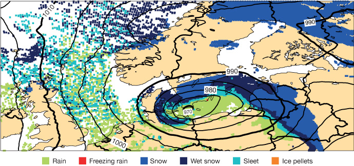
This forecast of precipitation type from 1 December 2021 at 00 UTC shows ECMWF’s high-resolution forecast valid on 2 December at 00 UTC, including mean sea-level pressure. It illustrates a predicted snow event in parts of Denmark and Sweden. More details can be found in ECMWF’s Newsletter No. 170.
Warnings and action
Skilful forecasts are important, but as the theme of this World Meteorology Day highlights, they are not enough. The translation into warning and actions is undertaken by national meteorological and hydrological services in our Member and Co-operating States, other WMO partners, commercial customers, the UN, and intergovernmental organisations.
Without those actors, our forecasts could never reach their full value. The process requires a meaningful engagement with communities at risk.
A great example, which is supported by ECMWF, is the use of forecasts for anticipatory action by humanitarian agencies, including National Red Cross and Red Crescent Societies and UN agencies, such as the World Food Programme and the Food and Agriculture Organization.
Forecast-based financing aims to fill gaps in the humanitarian system by using the science of weather and climate to anticipate possible impacts in risk-prone areas and mobilise resources automatically before an event. In principle, it is no different to you taking an umbrella with you when rain is forecast, but it operates on disbursing funds for people to act before the event.
Examples of such systems exist all over the globe. They use, for example, forecasts by the Global Flood Awareness System issued by the EU’s Copernicus Emergency Management Service, in which ECMWF is involved as the computational centre; multi-model seasonal forecasts provided by the EU’s Copernicus Climate Change Service run by ECMWF; or tropical cyclone forecasts by ECMWF. Our role is to support our community with the best possible data and products which can be used to generate early warnings and meaningful actions. This is how we all work together to reduce the risk to lives and livelihoods across the world.
