
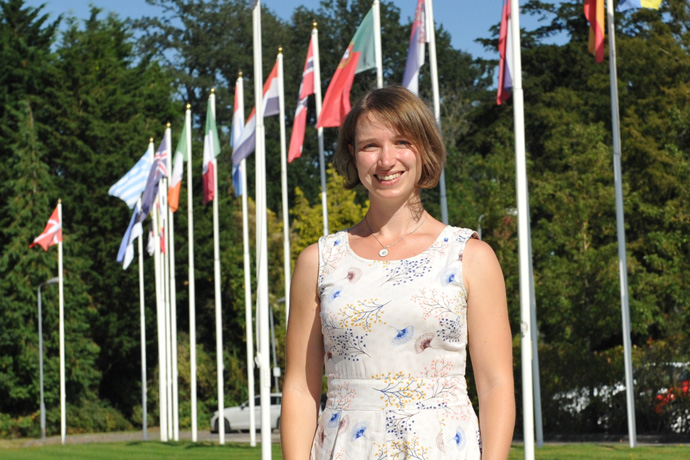
As ECMWF’s Annual Seminar on Observations gets under way, we take a look at Katie Lean’s work on satellites producing atmospheric motion vectors (AMVs) and a potential future constellation of small satellites carrying microwave sounding instruments.
Katie’s interest in meteorology dates back to a weather station in her garden at the age of 14. She went on to study physics at the University of Oxford and completed a master’s degree with a project on detecting large aerosol events in satellite images.
“I was interested in meteorology even before going to university,” she says. “That is why I focused on atmospheric physics in my degree course.”
Having worked on satellite observations at the Met Office for the next six years, she joined ECMWF in 2015, initially as a EUMETSAT Fellow. Her work concerns satellite observations used to help establish the initial conditions on which weather forecasts are based.
The general process of using observations to help establish the initial conditions (also known as the analysis) is called Earth system data assimilation.
Atmospheric motion vectors
Katie’s initial work at ECMWF was on AMVs. These are derived by tracking clouds or water vapour features through consecutive images from geostationary or polar-orbiting satellites. They provide important information on tropospheric winds.
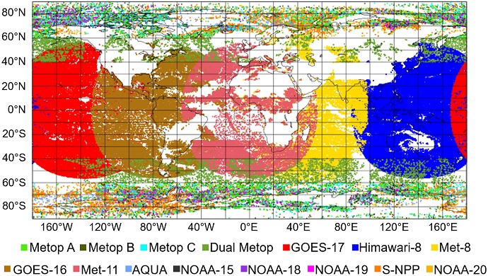
Typical AMV data coverage for a 12-hour assimilation cycle (00 UTC on 1 September 2021).
“I was responsible for all aspects of AMVs: adding new satellites, monitoring and maintaining the current system, and improving their use,” she says.
Katie did an in-depth study of Meteosat-8, which replaced Meteosat-7 in February 2017 as the official EUMETSAT geostationary satellite for the Indian Ocean.
She found that assimilating Meteosat-8 had a generally positive impact on forecasts. But she was concerned about an area in the Indian Ocean, where AMVs were potentially placed too high at relatively low levels (2–3 km height).
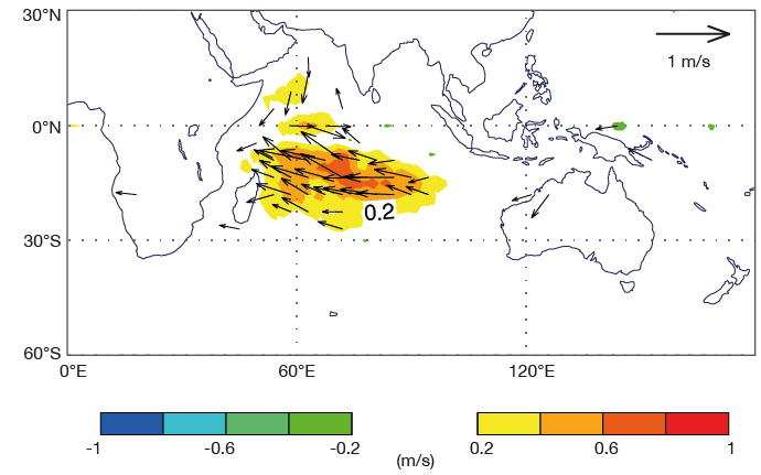
The chart shows the strengthening of the westward flow in the mean wind analysis at 850hPa when Meteosat-8 AMVs were included in data assimilation in experiments covering the period 21 October to 21 December 2016.
“One of the biggest sources of errors in AMV derivation is the assignment of height to the feature that has been tracked,” she explains. “A solution we developed was to use our own cloud layer height in the Integrated Forecasting System (IFS) to correct the heights of low-level winds diagnosed as potentially harmful.”
Katie found that this led to an improvement in low-level vector wind fields in the tropics.
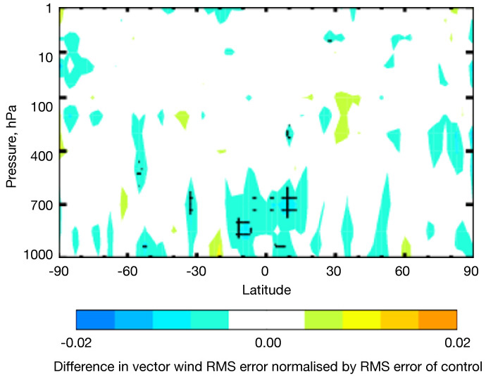
The plot shows the change in vector wind root-mean-square (RMS) error verified against own analysis at a 48-hour lead time, by latitude, comparing the control with no change to the data use to an experiment where affected AMVs are reassigned to the average pressure of the cloud layer. Blue colours indicate a reduction in the error, and the hatching indicates the 95% significance level. The error reduction is particularly pronounced in the tropical low-level wind field.
She also found small improvements compared to independent wind data from the Aeolus satellite.
The improved treatment of the AMV heights is to be included in the operational upgrade to IFS Cycle 47r3 planned for October this year.
“My EUMETSAT fellowship was a busy time,” she says. “In five years, we added eight satellites including replacing all geostationary satellites operationally assimilated in the IFS.”
Future satellite constellation
A year ago, Katie took over a new role at ECMWF, continuing to work in satellite data assimilation. Now she is investigating the optimal design of a future constellation of small satellites carrying microwave sounding instruments.
The European Space Agency (ESA) project is motivated by improved technology, which enables microwave instruments to be put on smaller satellites, making it possible to achieve greater temporal and spatial sampling in a more cost-effective way.
“This involves compromises because the platforms are smaller and lighter, but more satellites can be launched, and more quickly, to greatly improve the temporal coverage we get from microwave sounders,” Katie says.
The aim is to give ESA recommendations about optimal constellation design. The method Katie uses involves ECMWF’s Ensemble of Data Assimilations (EDA) system, which provides estimates of the analysis and short-range forecast uncertainties. To achieve this, the EDA runs multiple data assimilations in parallel using slightly perturbed observations, models and atmospheric boundary conditions.
“The principle is to use the EDA system and add in simulated microwave data. You then look at whether the data reduce the variation across the members of the EDA and thus reduce uncertainties in the forecast,” Katie explains.
She is looking at different numbers of potential satellites, and at having just humidity sensitivity or additional temperature sounding capabilities. So far the project has focused on preparation for running the EDA, including the technical set-up to generate and assimilate the simulated data.
Katie has also adapted the observation error model to assimilate the simulated data with a reduced set of frequencies compared to those typically available from the bigger satellite platforms. The list of potential constellations is soon to be finalised, allowing the start of the EDA experiments in the near future.
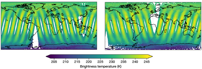
Maps showing good agreement between simulated brightness temperatures using the configuration for a potential small satellite (left) compared to bias-corrected observations from the equivalent frequency channel (54.4 GHz) on Metop-B AMSU-A (right).
Next steps
The interest in and use of small satellites is gathering momentum, and they are expected to become an important component of the observing system, complementing a backbone system of larger platform satellites.
“Some early, pathfinder missions are starting to emerge. However, we still have relatively little experience with the actual use of the data in numerical weather prediction systems,” Katie says. “It will be very exciting to see how the use of small satellite data evolves – there will likely be several challenges but also great potential to improve our forecast accuracy.”
