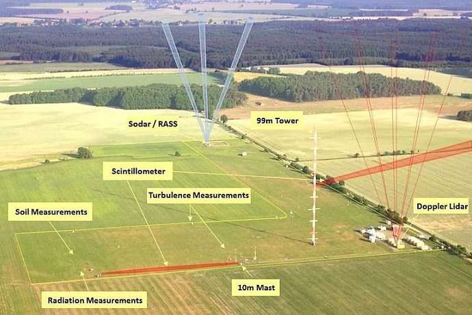

The facility in Falkenberg, Germany, is one of the sites from which observations have been used to assess the performance of ECMWF forecasts. (Photo: German national meteorological service, DWD)
In a recent concerted effort, ECMWF researchers have used detailed soil and weather observations up to about 200 metres above ground from several observational super-sites in Europe to assess different aspects of our weather forecasts.
This work has revealed certain patterns of forecast errors and provided new information about the processes responsible for these errors. Research is now ongoing at ECMWF to further improve near-surface weather forecasts based on lessons learnt from using the observations from these super-sites.
The importance of observational super-sites
The routine verification against observations at SYNOP stations provides a picture of forecast performance across a wide area, but provides only limited information about the causes of forecast errors since only a few variables are measured at each station.
In contrast, observational super-sites, maintained by national meteorological services and universities in several countries in Europe, collect tens or hundreds of variables allowing detailed investigation of atmospheric and coupled land–atmosphere processes and related forecast errors.
In a recent project focused on ‘Understanding uncertainties in surface–atmosphere exchange’ (USURF), ECMWF started to use data from several European super-sites more systematically than before.
The goal was to evaluate the quality of forecasts in the lowest part of the atmosphere and in the soil/snow and the ability of ECMWF’s Integrated Forecasting System (IFS) to realistically reproduce land–atmosphere interactions.
Mid-latitude super-sites
For the mid-latitudes, the focus was on temperature and wind observations from Falkenberg (Germany, associated with Meteorologisches Observatorium Lindenberg – Richard-Aßmann-Observatorium) and Cabauw (the Netherlands).
Monthly averaged diurnal cycles of temperatures at different heights in the air and different depths in the soil at Falkenberg at forecast day 4 for the months of June, July and August 2017. Predictions of ECMWF’s high-resolution forecast (HRES – grid spacing of 9 km) and ensemble forecast (ENS – grid spacing of 18 km) and of Germany’s ICON forecasting system are shown.
The plots above show some of the behaviour of ECMWF forecasts as well as German ICON forecasts compared to observations at the Falkenberg site. The same qualitative behaviour can be observed at Cabauw.
The main conclusion is that probably during the night too much energy is extracted from the soil and transferred to the atmosphere, especially for the IFS.
This may be related to problems in the thermal land–atmosphere coupling and the representation of vegetation in semi-arid areas. It results in an overestimation of 2-metre temperature during night-time.
Efforts to improve the representation of these processes in the IFS should be accompanied by a quantitative assessment of the representativeness of observations at the locations of SYNOP stations and super-sites. For more details, see the Newsletter article on the use of super-site observations and the blog by Polly Schmederer.
High-latitude super-sites
The observatories at Summit in Greenland and Sodankylä in northern Finland are particularly useful for investigating the quality of ECMWF forecasts over the cold, snow-covered surfaces which are typically found during winter in northern Europe.
Experiments have shown that 2-metre temperature forecasts at both sites depend significantly on the representation of snow in the IFS.
A manual snow survey takes place in Sodankylä. (Photo courtesy of Anna Kontu, Finnish Meteorological Institute).
Detailed measurements collected manually in snow pits at Sodankylä were used to evaluate a multi-layer snow model, developed and evaluated in the framework of the Horizon 2020 APPLICATE project, which will replace the single-layer snow model used currently in the IFS.
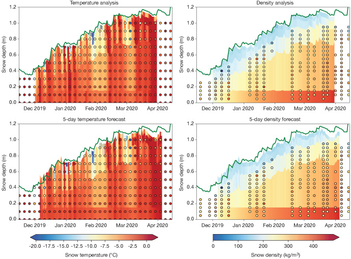
They demonstrated that the time evolution of snow temperature and density is more realistic when more layers are used to represent the snow.

Time–height plots showing the analyses of snow temperature (top left) and snow density (top right) at Sodankylä, and 5-day forecasts of snow temperature (bottom left) and snow density (bottom right), all with the multi-layer snow model (background colours) and observations (coloured dots) for the 2019/2020 season. The snow depth from observations is superimposed (green line). Observational data are courtesy of Anna Kontu (Finnish Meteorological Institute).
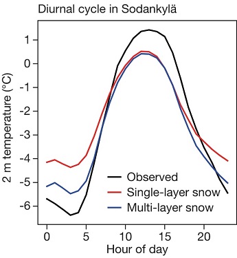
It was found that using this new multi-layer snow model reduces errors in 2-metre temperature at both sites.

March–April 2014 mean diurnal cycle of 2 m temperature at Sodankylä in observations and in the ECMWF forecasting system with single-layer and multi-layer snow. The chart shows that the underestimation of the amplitude of the diurnal cycle of 2-metre temperature is partly the result of using a single-layer snow model.
Observations of energy fluxes showed that the improvements in temperature forecasts were happening for the right reasons at both locations.
The way ahead
Research carried out to improve weather forecasts needs detailed observations. This was further demonstrated by the recent use made at ECMWF of observations from super-sites within and outside Europe.
ECMWF is taking a leading role in international initiatives using super-sites, such as YOPPsiteMIP (an initiative of the World Meteorological Organization’s Year of Polar Prediction) and the Horizon 2020 project INTERACTIII, which aim to further the exploitation of research station data to improve forecasts in the Arctic.
As the reliance of numerical weather prediction centres on these observations increases, so will the need for timely homogenised data of high quality which can be used in the evaluation of model cycles. Such homogenisation efforts do exist (e.g. FluxNET and SRNWP), but usually they have a lag of some 2–3 years.
Further work is also required to solve all the modelling issues that have been highlighted by research carried out using observations from these sites.
The most immediate change that will be made to ECMWF’s forecasting system is from a single-layer snow model to a multi-layer snow model to reduce errors in temperature and snow forecasts over snow surfaces. This is expected to be part of IFS Cycle 48r1 to be implemented at the end of 2022.
