
Photo: Abdul Manna
Floods impact billions of people worldwide and, with the likelihood of extreme weather increasing with the changing climate, this number is only expected to increase. Today, to mark International Day for Disaster Risk Reduction, we take a look at a range of major new upgrades to the European Flood Awareness System (EFAS) that will bring a step change in resolution and deliver a huge volume of open-access data, fundamentally changing the way the forecasts are calculated and the quality of what is being provided. We also explore how the Global Flood Awareness System (GloFAS) helped communities prepare for, and recover from, this summer’s monsoon floods in Bangladesh.
The two systems, EFAS and the complementary GloFAS, are produced by ECMWF as part of the Copernicus Emergency Management Service (CEMS). Both systems provide flood forecast information, independent of administrative and political boundaries, to support preparatory measures in anticipation of major floods. The forecasts provide information on when flooding will commence, how long it will last, and whether there will be one flood event or many.
“By exploring risk on a regional scale, our systems are invaluable to a wide range of stakeholders that support flood risk management,” explains Professor Christel Prudhomme, manager of the computational centre of EFAS and GloFAS. “We can support local authorities, international organisations and humanitarian agencies by providing consistent information that can be used as a stand-alone tool or to complement existing data.”
Key new EFAS upgrades
While the current version of EFAS is already widely used, this week sees the launch of EFAS4.0. The new version follows a complete upgrade of its hydrological modelling system.
The new version includes several new products, as well as changes in the way that flood warnings are calculated. Perhaps most important is a model upgrade that takes the twice-daily forecasts from 24-hour increments right down to six hours. This reduction in time step will provide much-needed detail that is currently masked. This means that, for example, it will be easier to define the timing and relative size of the flood peaks, creating a much more accurate estimate of risk.

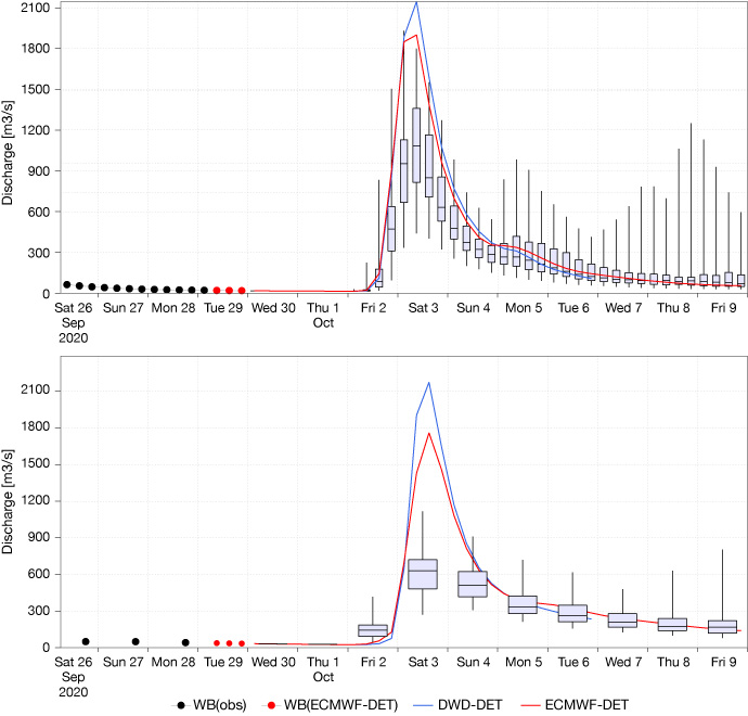
Two EFAS hydrographs from recent floods in Italy. The box plots represent data outputs from the ECMWF forecast. The top hydrograph is from EFAS4.0 and the lower hydrograph is from the current system. The median value of the box plot (indicated by the horizontal line) at the peak reaches ~1000m3/s in EFAS4.0 but only reaches just over 600m3/s in the current production system.
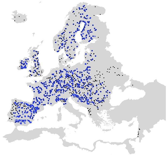
Another aspect that impacts the model is a 60 percent increase in calibration points across a range of different countries. This will help the EFAS team to check and tune the hydrological model used to create forecasts, and to issue forecasts showing considerably more detail. In addition, the provision of such a wealth of additional data from the partner organisations is testament to the success of, and widespread support for, the system.

Map showing the river station calibration points used for EFAS. Blue dots are the 717 points for the current system; black dots are the 1137 points for EFAS4.0.
New static layers describing hydrological modelling features are also being added, with information on drainage networks, the locations of lakes and reservoirs, and the location of fixed reporting points. Forecasts are created based on a digital representation of the real world, so these new layers increase the accuracy of that representation. This is vital information for forecasters needing to understand the limitations of the model used.
Besides the model upgrades, the new version of EFAS also includes a ‘forecast skill’ layer which shows information about the quality of the forecasts. This will help users understand the confidence levels of the simulations of river flows and flood forecasts.
As part of ECMWF’s wider move towards open access and transparency, a huge volume of ‘re-forecast’ or ‘hindcast’ EFAS data are also being made available via the Copernicus Climate Change Service’s Climate Data Store from 14 October. Advanced users can access this information to assess the quality of the EFAS forecasts for their local areas, and so choose how best to use the information provided.
Flood forecasts in real world situations
This is a massive upgrade for EFAS, but just the first of several big changes planned for both systems. With climate change impacting rainfall distribution and volume, it is vital that forecasting tools continue to improve in order to help protect life, property and the economy on a global scale.
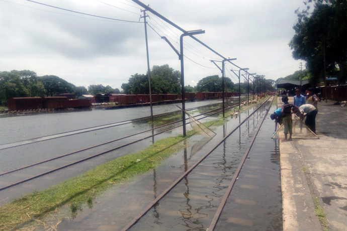
One recent example was the use of GloFAS to mitigate the impacts of monsoon floods in Bangladesh that caused widespread devastation this summer. Over five million people were affected, there were 41 casualties and tens of thousands of people were evacuated with their livestock. But the impacts could have been considerably worse, and the numbers of casualties much higher, without the early warning provided by GloFAS.
Providing forecasts with sufficient lead-time is challenging but can make a massive difference in allowing policymakers to react. For example, in Bangladesh, the flood forecasts delivered with a 10-day lead-time meant there was opportunity for local authorities to warn vulnerable communities. This was also a great test of the related ‘forecast-based-financing’ model used by a number of humanitarian agencies which leads to the release of funds before an event.
“We have been using 30-day GloFAS forecasts since 2017 to predict the timing and duration of monsoon floods,” says Sazzad Hossain, Flood Forecaster from the Flood Forecasting and Warning Centre in Bangladesh. “The forecast information is communicated to a range of stakeholders to support their flood preparedness and emergency response actions to mitigate damage. For instance, during the 2020 floods, GloFAS forecast information such as start date, peak time of floods and duration were communicated to humanitarian agencies and disaster managers well in advance. Their early actions empowered communities to protect their lives and livelihoods by taking appropriate flood preparedness decisions.”
“We are really proud to be able to produce these tools which have the potential to positively impact on so many lives. It is exciting to see what the new upgrades will mean for our wide range of users,” concludes Christel.
GloFAS data are freely available through a dedicated website and via the Copernicus Climate Change Service’s Climate Data Store (CDS). EFAS has more restricted access, but some data are available via the CDS and the EFAS website.
