
Predicting warm conveyor belt ascending air flows in extratropical cyclones and their impacts on the weather remains a key challenge for forecasting.
A workshop at ECMWF from 10 to 12 March 2020 will bring together a wide range of international experts to discuss the latest research on warm conveyor belts, gaps in our knowledge and the way forward for improving forecasts in the future.
Impacts
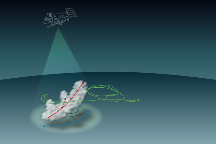
A warm conveyor belt (WCB) is an ascending, poleward-moving warm moist airstream in the warm sector of extratropical cyclones. There can be a lot of precipitation associated with WCBs, which can lead to flooding as well as other downstream impacts.
“When a warm conveyor belt arrives at 10 km altitude, it interacts with the jet stream. In some cases, this can contribute to the subsequent development of ‘blocking’ conditions, in which high pressure dominates,” says ECMWF Fellow Heini Wernli, who has worked on this issue with his team at ETH Zurich. This has implications for weather and climate prediction, for example the expected frequency of droughts.
Open questions
There is still much to learn about WCBs. “An open question is the respective roles of dry and moist processes in the rapid growth of uncertainty in these situations,” says ECMWF scientist Mark Rodwell, one of the workshop organisers. “Understanding this better could have a major impact on our research and development strategy.”
From a forecasting point of view, it is also unclear whether existing observations are sufficient to initialise WCBs in our forecasts. “We need to examine what the current WMO Integrated Global Observing System (WIGOS) can provide that is relevant to WCBs, identifying strengths and weaknesses,” says Stephen English, Head of ECMWF’s Earth System Assimilation Section.
The complex moist physical processes within WCBs also represent a significant challenge to modelling. “New data from satellite missions and observing campaigns could help us improve the modelling of WCBs,” says Richard Forbes, who works on the microphysics of clouds and precipitation at ECMWF.
“We think that the time is right to get different communities together to tackle warm conveyor belts in weather forecasting from different angles,” says Mark, “as forecasting is at a point where such details are key to future improvements in forecast performance.”

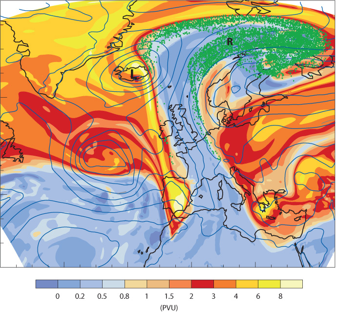
The chart shows a WCB event associated with a low-pressure system near Iceland (L). The WCB is seen to transport low values of potential vorticity (blue shading) from the subtropical lower troposphere to the extratropical upper troposphere. Green dots show where ascending air parcels associated with the event reach the upper troposphere (the 310 K surface of constant potential temperature) and thus contribute to the formation of an upper-level ridge (R). (Figure from Joos & Wernli, 2012, doi:10.1002/qj.934)
Clouds and convection
Clouds and convection play an important role in the development of WCBs. In recent work, Heini’s group at ETH Zurich has studied the trajectories of air parcels in WCBs more closely.
“In high-resolution simulations as well as observations from field campaigns, we can see that embedded convection may locally significantly accelerate the otherwise gradual ascent of air parcels in WCBs,” Heini says. “This can also have an impact on the evolution of large-scale weather conditions downstream.”
Another question Heini’s team has worked on in collaboration with ECMWF is how the interaction with the jet stream is influenced by microphysical processes, such as the freezing of liquid droplets and the formation of snow and ice particles in WCBs.
Again, observations from satellites or field campaigns can provide important clues. They can point to shortcomings in the current model formulation, and they can be used to assess any modifications of the model.

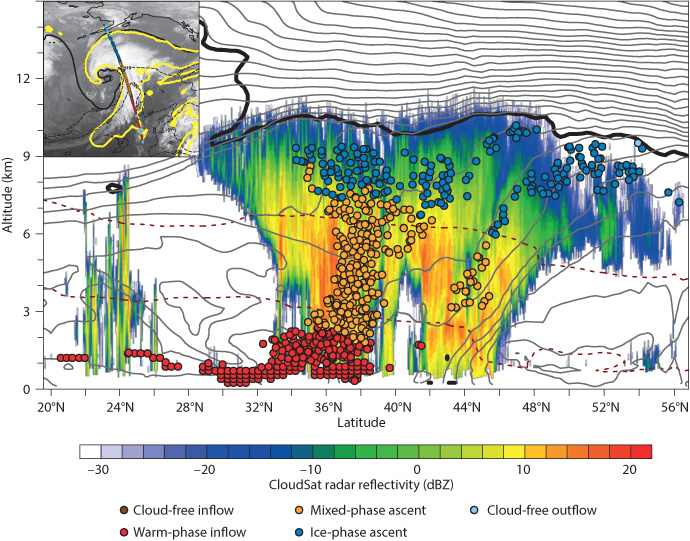
In this chart, the modelled cloud phase of WCB air parcels is overlaid on CloudSat radar reflectivity satellite observations at 00 UTC on 3 January 2014 along the line indicated in the inset. Although there is no direct relationship between cloud phase (liquid water, mixed water and ice, or just ice) and radar reflectivity, such observations can help to identify model deficiencies. (Figure courtesy of Hanin Binder)
“Some exciting new observations have recently become available, such as wind profile observations from ESA’s Aeolus satellite, and over the next few years they should be followed by cloud profile observations from ESA and JAXA’s EarthCARE satellite mission,” says Richard.
“However, field campaigns using aircraft also have a role to play as they can provide in-situ measurements at times and in locations of particular interest.”
Predictability
Observational and modelling work can in turn be guided by diagnostics: investigations into the source of forecast errors and of uncertainty in the prediction of WCBs and downstream weather developments.
For example, work carried out at ECMWF suggests that the presence of WCBs considerably amplifies uncertainty in forecasts of winds in the upper troposphere downstream from WCB events.

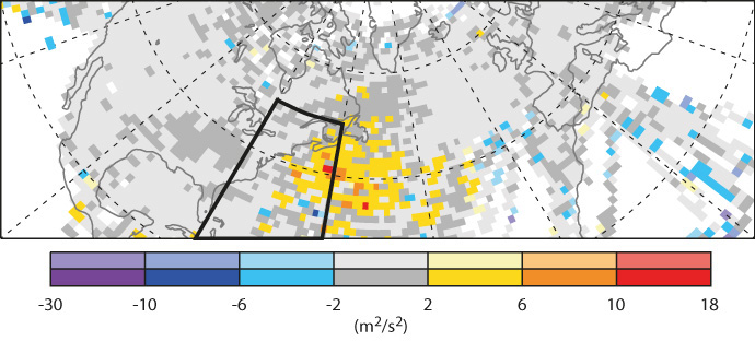
The shading in the figure shows the difference in forecast uncertainty between composites of 50 WCB events (with inflow in the box indicated the day before) on the one hand and 87 non-WCB situations off the east coast of North America on the other: after one day, such events lead to an increase in uncertainty in upper-tropospheric winds compared to non-WCB situations. In technical terms, the chart shows the difference in Ensemble of Data Assimilations background variance in zonal (east–west) winds at 200 hPa.
The workshop in March will bring together specialists in atmospheric dynamics, cloud microphysics, observations, diagnostics and data assimilation.
“It is only by combining expertise spread out over different communities that we can improve the prediction of WCBs and their impacts on the subsequent evolution of the weather,” says Mark.
Further information
Web page on the workshop on ‘Warm conveyor belts – a challenge to forecasting’ from 10 to 12 March. The talks will be live-streamed (the link will be provided at a later date).
ECMWF Newsletter article on ‘Why warm conveyor belts matter in NWP’, published in January 2018.
