
Several European national and city temperature records tumbled this summer during two separate heatwaves in June and July. How well can such extreme events be predicted using a state-of-the-art global forecasting system?
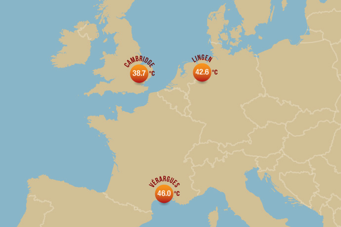
We have looked at ECMWF’s 2-metre temperature forecasts for three locations where national records were broken. These records are 46.0°C in the French village of Vérargues on 28 June; 42.6°C in the town of Lingen in Germany on 25 July; and 38.7° in the city of Cambridge in the UK on 25 July. The July heatwave also set new temperature records in Belgium, Luxembourg and the Netherlands.
Key findings are that
- warmer than average temperatures were predicted between 10 and 12 days ahead of the three events considered here
- highly unusual temperatures were predicted between 6 and 7 days ahead, but there are variations in how confident the predictions were
- even in the shortest-range forecasts, the predicted temperatures are a few degrees lower than the observed records.
To understand these findings, it is important to bear in mind two things:
- The forecasts were not for the specific points where the records were broken. This is because numerical weather prediction covers the world in a grid. Based on a set of initial conditions and using the laws of physics, it then calculates average predicted weather variables for each grid box.
- ECMWF produces two types of forecast: ensemble forecasts (ENS) with a grid spacing of 18 km, and high-resolution deterministic forecast (HRES) with a grid spacing of 9 km. An ensemble forecast is a collection of forecasts using slightly perturbed initial conditions and models to reflect inevitable uncertainties in the forecast. The spread of the ensemble members gives an indication of how confident the prediction is.
Let’s now look at the predictions made by ENS and HRES for the three locations.
Vérargues: 46.0°C
Successive ENS and HRES forecasts for maximum 2-metre temperature on 28 June for the grid box containing Vérargues are shown below.

The blue box-and-whisker symbols indicate the range of predicted values in each ENS forecast. The red box-and-whisker symbol shows the climatological range of temperatures in that grid box.
The ensemble started to predict above-average temperatures 10 days ahead of the event, and as early as 7 days ahead most ensemble members predicted top temperatures in excess of the 99th percentile of the local climate.
Although more than three days ahead the ensemble was very confident of temperatures well above the 99th percentile of the local climate, even the shortest-range ENS and HRES forecasts remained below the 46°C recorded at Vérargues.
There are two reasons for this. One is that the predictions were for average conditions in the grid box as a whole. They did not take into account local variations, for example in soil moisture and vegetation.
The other is that, in common with other global forecasting systems, ECMWF forecasts have biases in near-surface predictions. These include a tendency, in many parts of Europe, to underpredict maximum temperatures in summer. Possible ways to remedy this are being investigated.
Lingen: 42.6°C

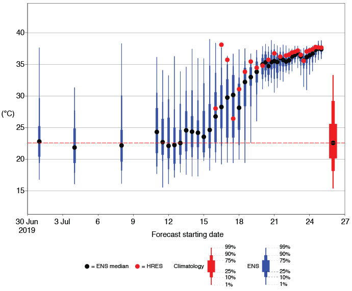
The ensemble started to predict warmer than average conditions 12 days before 25 July. In subsequent forecasts, predicted top temperatures steadily rose. Six days ahead, most ensemble members predicted top temperatures above the 99th percentile of the local climate.
Once again, predicted temperatures remained a few degrees below the 42.6°C recorded at Lingen, for the reasons outlined above for the case of Vérargues.
An interesting feature in this case is a high degree of jumpiness in HRES forecasts 8 to 9 days ahead of the event, with a prediction of about 38°C one day and 26°C the next.
A forecaster looking just at the HRES would have had no way of knowing what confidence to attach to these different forecasts. The ENS forecasts provide a fuller picture. They show that the HRES forecasts were made at a time when uncertainty was still high and that they were part of a large spread of possible outcomes.
Cambridge: 38.7°C

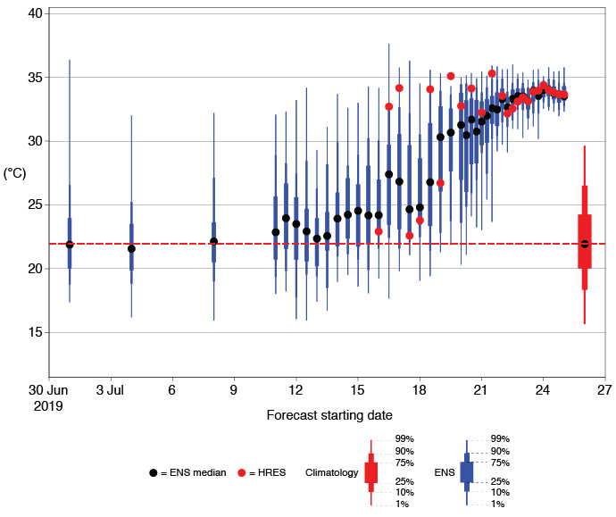
The ensemble started to consistently predict warmer than average conditions 11 days before 25 July, and six days ahead most ensemble members predicted top temperatures above the 99th percentile of the local climate.
However, in this case the range of predicted possible outcomes remained relatively large until about 4 days ahead of the event. This is because until then it was not clear how far west exactly the southerly flow bringing highly unusual temperatures would reach.
Between about 8 and 9 days ahead, the HRES forecasts for Cambridge once again show some big jumps, between about 23°C one day and about 34°C the next. The evolution of the ENS is much more consistent and shows that the HRES forecasts are different possible realisations in a situation marked by great uncertainty.
In Cambridge, too, the predicted temperatures remained well under the recorded 38.7°C, which may have been boosted by the location of the measuring station in an urban environment.
How good were the forecasts?
ECMWF’s medium-range forecasts provided good advance indications of highly unusual temperatures in the three locations shown.
There was overall good consistency between successive forecasts and high confidence that extreme temperatures would occur as early as about a week in advance.
Nevertheless, the predicted temperatures did not quite match the national records, for two reasons. The first is that, in any global forecasting system, predictions are made for average values in grid boxes which are typically at least about 10 km wide.
The second is that, in common with other global forecasting systems, in many locations in Europe there are known biases in ECMWF’s near-surface forecasts, including a tendency to underpredict maximum temperatures in summer.
Although biases can to some extent be removed statistically, there is value in having less biased direct model output, and for this reason addressing biases in near-surface forecasts is an active area of research at ECMWF.
Initial results show that such biases are closely related to the coupling between the atmosphere and the land surface, but work to identify and isolate the influence of the different factors involved is continuing.
