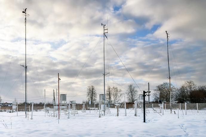

Weather station observations provide important information on the current state of the Earth system. (Photo: NataliaVo/iStock/Thinkstock)
Accurate and timely weather data from across the globe are crucial for numerical weather prediction (NWP) since they help to determine the initial conditions from which forecasts start.
In a welcome development, Ukraine has recently begun to provide additional weather station observations to ECMWF in real time.
The timely delivery of these observations of temperature, wind, precipitation, humidity, cloud cover and other variables means they can be used to help initialise forecasts.
Both sides stand to benefit: the extra data will help ECMWF to improve its global forecasts, and better global forecasts will in turn help to initialise improved higher-resolution regional and national forecasts.
Experiments carried out at ECMWF illustrate the gains additional weather station observations can bring.
More data from Ukraine
Ukraine routinely puts observations from more than 30 weather stations on the Global Telecommunication System (GTS).
The stations are part of a global network managed by national weather services under the auspices of the World Meteorological Organization (WMO). They can be used freely by operational centres such as ECMWF as well as any WMO Members.
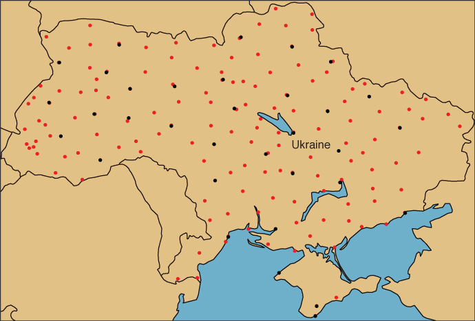
Recently Ukraine agreed to make observations from about 130 additional weather stations available to ECMWF.
“This five-fold increase is a very welcome addition to the weather data from Ukraine we have been able to get via the GTS,” says Patricia de Rosnay, the Leader of ECMWF’s Coupled Assimilation Team.

More observations. ECMWF has recently begun to use additional weather observations from Ukraine to help initialise its forecasts. Black dots show the location of weather stations in Ukraine providing data to the GTS and red dots the location of stations in Ukraine providing additional data, in this case snow depth observations on 28 February 2018.
Impact of more observations
Weather station observations of temperature, humidity and pressure improve forecasts of those variables.
Near-surface temperature and humidity observations also help to estimate soil moisture levels, which in turn influence forecasts of near-surface temperature and rainfall several days ahead.
Snow depth is another variable that matters because it has a major influence on forecasts of other variables, such as near-surface temperature.
In recent years, several European countries have agreed to share additional snow depth observations with ECMWF.
Experiments show that the additional data improve forecasts.
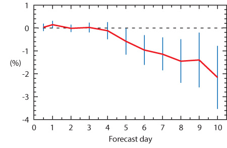
For example, extra snow depth data from national monitoring networks in Denmark, Hungary, the Netherlands, Norway, Romania, Sweden and Switzerland have improved two-metre temperature forecasts.

Reduced forecast error. The graph shows that the error in ECMWF forecasts of 2-metre temperature in the northern hemisphere is reduced by up to about 2% as a result of the use of additional snow depth data from European countries. Significant reductions in root-mean-square error can be seen from forecast day five. The forecasts were verified in the period 1 December 2014 to 30 April 2015, 20°N to 90°N, against own analysis. The vertical bars indicate 95% confidence intervals.
Additional weather station data do not just help to improve the initial conditions on which forecasts are based, they can also be used to verify forecasts.
“The provision of timely additional weather observations by countries such as Ukraine is thus extremely useful,” Patricia says.
“It helps us to improve our forecasts and our forecasting model for the benefit of all our users.”
