
Our global numerical Earth system model
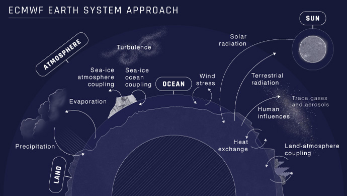
A global numerical model of the Earth system underpins all ECMWF forecasts. It has been developed to encompass not just the atmosphere, but the ocean, waves, land and sea ice, and their interactions. Our model is key to ECMWF's Integrated Forecasting System (IFS), which is used to produce all our forecasts from days to seasons ahead. Today, ECMWF’s forecasting system is recognised as one of the best in the world.
The global Earth system approach used by ECMWF is driven by our fundamental mission to provide skilful medium-range forecasts for our Member and Co-operating States. Furthermore, it has opened up the possibility of providing a wide range of broader environmental services such as monitoring climate change and forecasting floods, air pollution and wildfires.
Our model has been developed over decades in close collaboration with our Member and Co-operating States and with input from many other collaborators. Code infrastructure is shared and co-developed, and the forecasting system upgrades are coordinated with Météo-France, who have worked with us particularly on the atmospheric model component. Other components have been developed from community models, such as the NEMO (Nucleus for European Modelling of the Ocean) ocean model and the Louvain-la-Neuve Sea Ice Model (LIM2).
From atmosphere model to Earth system model
When ECMWF first issued its forecasts more than 40 years ago, our numerical model represented only the atmosphere, with simplified interactions with the land surface. Information about the ocean, sea ice and many aspects of the land surface, for example, were input to the model from external datasets and so they did not evolve dynamically in response to changes in the atmospheric flow.
The need to represent interactions between Earth system components was driven in part by the development of seasonal forecasts at ECMWF, but it is also important for skill in the medium range.
For example, ocean/sea-ice and atmosphere coupling has significantly improved forecasts of tropical cyclones which draw on energy from the warm ocean surface and can also affect the ocean state. Land/atmosphere interactions need to be represented well to produce skilful forecasts of near-surface weather conditions, such as temperature, for which the exchange of energy and moisture between the land and atmosphere is very important.
In an Earth system numerical model, processes at scales larger than the model grid are directly represented by solving equations which represent the motion of air (and water in the ocean). Processes at smaller scales (clouds, turbulence, or land-surface and radiative processes) are parametrized by making assumptions about their effects on temperature, moisture or winds.
Over time, more components and processes are being taken into account in ECMWF’s model, with particular attention on the coupling between them. Processes are being represented more realistically and at higher resolution. For example, ECMWF’s high-resolution forecasts have a grid spacing of around 9 km in the atmosphere, this compares with a resolution of more than 100 km in the first operational weather forecasts.
Earth system observations and data assimilation
The quality of ECMWF’s forecasts owes much to the accuracy of the initial starting conditions, as well as the realism of its Earth system model. The initial starting conditions (or analyses) are produced through data assimilation – where millions of observations of the Earth system are optimally combined with short-range forecasts.
For the atmosphere, ECMWF uses a system called four-dimensional variational data assimilation (4D-Var) – an approach launched in 1997 which has been continuously developed and improved. The powerful ability of 4D-Var to assimilate a wide variety of observations results in high-quality analyses, and depends partly on the quality of our Earth system model.
If the short-range forecasts used in the data assimilation process are too far from the observations, the observations cannot be used optimally. This means the positive impact of observations may be reduced and in some cases they cannot be used at all. So, alongside improvements in the data assimilation itself, a more accurate short-range forecast also improves the use and impact of observations, and hence initial conditions for the next forecast.
4D-Var and the high quality of our Earth system model, including the modelling of the observations themselves, paved the way for a breakthrough known as ‘all-sky’ data assimilation. Before that, it was difficult to use satellite data from areas affected by clouds and precipitation. That left large areas of the globe with only sparse ground-based measurements to keep the forecast grounded by observations.
The ‘all-sky’ system, which continues to bring benefits, has only been possible because of extensive research to improve the representation of clouds and precipitation in the forecast model, and our understanding of how these ‘moist processes’ affect satellite radiances.
Environmental services and community modelling
ECMWF’s Earth system model is now being used for a wide range of impact-related environmental applications and services, such as forecasting flood risk and air quality.
ECMWF implements the Copernicus Climate Change Service (C3S) and the Copernicus Atmosphere Monitoring Service (CAMS). We also contribute to the Copernicus Emergency Management Service (CEMS) and work closely with the Copernicus Marine Environment Management Service (CMEMS). These applications have been made possible by sustained efforts to expand our modelling to encompass a wide range of Earth system processes and interactions.
Air quality and increasing levels of greenhouse gases in the atmosphere are of huge concern. ECMWF’s IFS is used within CAMS to provide a range of operational services, such as forecasts of European air quality, information for the solar energy sector, and monitoring of the ozone layer.
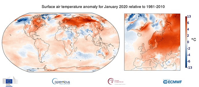
ECMWF’s reanalyses provide the most complete picture possible of past weather and climate across the globe. They are obtained by blending short-range forecasts with past observations using our IFS 4D-Var data assimilation process. ECMWF’s latest reanalysis, ERA5, forms the basis for monthly C3S climate bulletins.

Surface air temperature anomaly for January 2020 relative to 1981–2010. Data source: ERA5. Credit: Copernicus Climate Change Service/ECMWF.
ECMWF runs the computational centre for the European Flood Awareness System (EFAS) – an element of CEMS. The Centre also runs and manages the Global Flood Awareness System (GloFAS) and has a role in a wildfire information system as part of CEMS. It is the quality of ECMWF’s analyses and forecasts that makes it possible to realistically model flood and fire risk.
OpenIFS is a version of the IFS used widely by universities, research institutes and the meteorological services of ECMWF’s Member and Co-operating States for a range of uses (including climate modelling).
OpenIFS and other elements of ECMWF’s IFS form part of EC-Earth, a European Earth system model developed as a community tool by a European-wide consortium. EC-Earth is being used widely to advance scientific knowledge of the Earth system and its climate, and to help develop climate services.
How will ECMWF’s Earth system model develop in the future?
One of our operational goals is to improve forecasts of high-impact weather several weeks in advance. Our Earth system model will remain at the heart of scientific developments to achieve this.
As part of our Strategy to 2030, ECMWF is also launching a new initiative in data assimilation called ‘all-sky, all-surface’ to make greater use of satellite data over land, snow and sea ice. This development relies strongly on further improving the way we represent land-surface and sea-ice processes in our Earth system model.
Greater accuracy and detail near the land surface in our analyses and forecasts will also be extremely beneficial to wider environmental applications and sectors.
The emergence of exascale supercomputers is now making kilometre-scale global Earth system modelling a possibility. For comparison, in early 2022 our medium-range high-resolution forecasts had a horizontal resolution of 9 km.
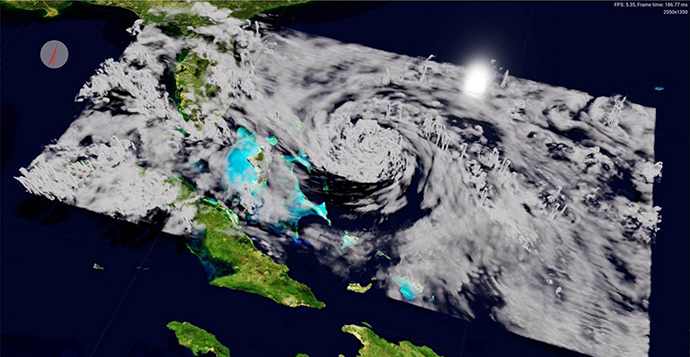
At resolutions near 1 km it is possible to resolve, at least in part, deep convection – a major step forward in global numerical models of the Earth system. Deep convection refers to plumes of warm, moist air that rise through the atmosphere and it occurs at scales smaller than current global model grids. It plays a key role in the re-distribution of energy and moisture in the tropics, driving the wider-scale circulation, and influencing mid-latitude weather.

This 1 km simulation captures the intricate cloud structure of category 5 hurricane Dorian making landfall in the Bahamas on 1 September 2019. Image in collaboration with NVIDIA, created by OMNIVERSE
The NextGEMS project is helping advance Earth system modelling at kilometre scale. Two prototype kilometre-scale (or storm- and eddy-resolving) global Earth system models will be developed – one based on ECMWF’s IFS (coupled with NEMO and the FESOM2 model from the Alfred Wegener Institute), the other on the ICON model from the Max Planck Institute for Meteorology (MPI-M) and the German Weather Service. NextGEMS offers the opportunity to tackle some of the biggest knowledge gaps in weather and climate science.
Simulations at kilometre scales will underpin ECMWF’s operational forecasts by the end of the decade.
A digital replica of planet Earth
ECMWF’s Earth system modelling capabilities are set to make a major contribution to an ambitious European Commission initiative to create a digital replica of planet Earth. In this Destination Earth (DestinE) programme, we will work alongside institutions such as the European Space Agency (ESA) and the European Organisation for the Exploitation of Meteorological Satellites (EUMETSAT).
Our role is to build the ‘digital twin engine’ software and data infrastructure, and to use it to deliver the first two high-priority digital twins. The Digital Twin on Weather-Induced and Geophysical Extremes will provide capabilities for the assessment and prediction of environmental extremes. The Digital Twin on Climate Change Adaptation will support the generation of analytical insights and testing of predictive scenarios in support of climate adaptation and mitigation policies at multi-decadal timescales, at regional and national levels.
The digital twins will draw on our world-leading expertise in global numerical weather prediction and our expertise in advanced high-performance computing, data handling and machine learning demonstrated on some of the largest infrastructures in the world. It is the quality of ECMWF’s Earth system modelling and data assimilation system, built from many years of collaborative development, that makes this ambitious goal possible.
DestinE takes forward long-term investments of ECMWF Member States in building a unique European prediction capability and will support the further development of Member State and European services, like the Copernicus services.
The evolution of our operational forecasting system
Developments in our global numerical model and data assimilation system are regularly brought into our operational forecasts. Upgrades are implemented typically once a year, and exceptionally twice a year like in 2021.
In 2023 we will see a major upgrade to our forecasting system. The key change will be a significant increase in the horizontal resolution of our medium-range ensemble forecasts from 18 km to 9 km, bringing the 50‑member ensemble to the same level as our current high-resolution forecast. Cycle 48r1 will also bring a major upgrade to the configuration of the extended-range ensemble. Rather than being an extension of the medium-range forecasts starting twice a week at day 15, it will be a completely separate system, running daily from 00 UTC out to day 46 with 100 members. Cycle 48r1 will be the first ECMWF forecast upgrade to be produced in our new data centre in Bologna, Italy.
This cycle upgrade represents a significant step forward on ECMWF’s journey to provide ever more skilful forecasts of the weather phenomena that affect us most.
