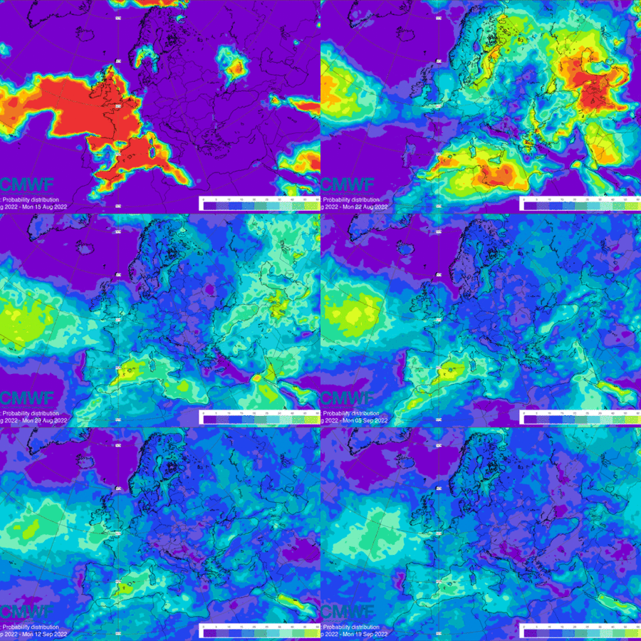

This chart shows information regarding probabilities for the 7-day mean anomalies of air temperature at 2 m to be in the lower or upper parts of several selectable categories derived from the ECMWF ensemble (ENS).
Another heatwave is currently affecting most of Europe with various and very high intensity levels. This follows heatwave conditions across Europe earlier this summer, which have now contributed to large parts of Europe also experiencing severe drought conditions.
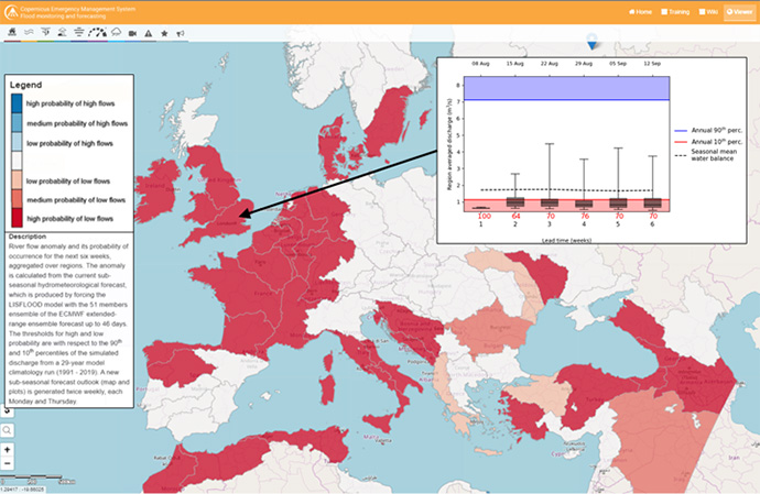
The drought that started in early summer as a consequence of low precipitation amounts over four consecutive seasons across Europe is persisting into late summer. The precipitation deficit is still severe, causing low soil moisture, high vegetation stress, low river flows and water shortages in many areas across Europe. The extended-range hydrological forecasts from the Copernicus Emergency Management Service show that this situation is likely to continue into the late summer for most of western Europe.

EFAS sub-seasonal forecast with the severe low flow signal in many parts of Europe in the next six weeks, with the inset hydrograph highlighting the evolution of weekly mean river discharge in the southern part of the UK.
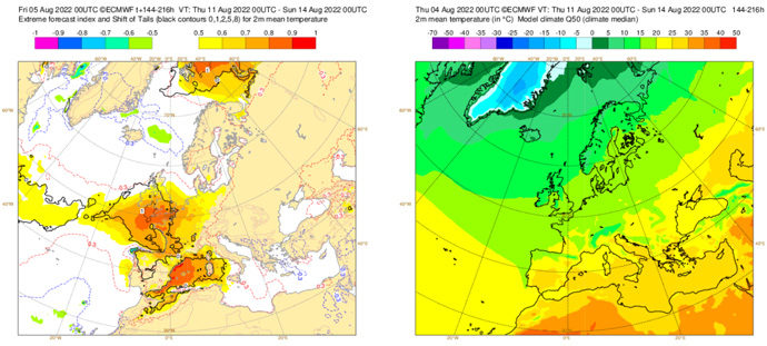
The surge of heat of 11–13 August, mainly affecting northern Spain, western France, Ireland and UK, can be seen in the short-range Extreme Forecast Index (EFI) for 2-metre temperature. Looking at the forecast issued one week ahead (5 August), the EFI product captured well the spatial pattern of the heatwave and gave a reasonable early warning for the event. The EFI product also highlights the very warm sea in the western Mediterranean.

These charts aim to provide pointers to areas where anomalous values of 2 m temperature are likely to occur based on the ECMWF ensemble forecast (ENS) system. You can access animated EFI charts here, where you can select desired times and climatology quantiles using the drop down menu. Date/time can also be selected using the slider underneath the chart or the play/pause symbols at the bottom left of the chart.
Our extended-range forecasts provide a broader overview for the coming four to six weeks. These forecasts are generally provided as seven-day averages in terms of anomalies relative to what is expected for the time of year.
For example, the 2 m temperature: Weekly mean anomalies chart shows for this week temperatures up to 10°C higher than average in parts of northern Spain, western France and southern England. Much of northern Spain, France, the UK, Belgium, Luxemburg, the Netherlands and western Germany will be up to 6°C higher than average. Next week, these extremes will have mostly dissipated, although a large part of northern Europe is predicted to see temperatures 3°C higher than average. Over the following weeks, this area of warmer-than-average temperatures moves to western Europe where it remains into September.
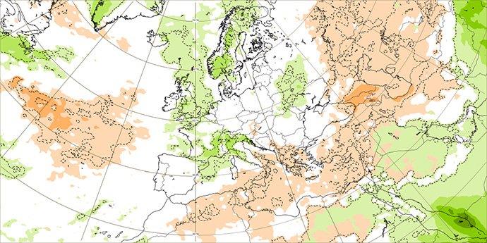
Despite the continuing warm weather, drought conditions are expected to ease over the next few weeks. Our Precipitation: Weekly mean anomalies product shows that, while this week precipitation remains at 30% lower than average over much of northern Europe, and as much as 60% lower in some regions, next week will bring higher-than-average precipitation to a region stretching from Scandinavia, across much of the UK, through France to the Mediterranean Basin. Parts of eastern Europe will also see higher-than-average precipitation. In late August, Portugal, Spain and parts of western France will see two weeks of lower-than-average precipitation. By early September, however, precipitation will be around average for most parts of Europe.

Screenshot of chart showing the seven-day mean anomaly of precipitation (in mm) for Monday 15 August to 22 August 2022. It can be seen that conditions will be close to average for much of Europe, with some areas experiencing slightly higher-than-average precipitation.
Looking further ahead still, our long-range, or seasonal, forecasts, which provide information on conditions up to seven months ahead, show that warmer-than-average temperatures are likely to persist over much of Europe until October, with southern and northern regions experiencing warmer-than-average temperatures to the end of the year. Precipitation is likely to remain lower than average in Portugal, as well as western parts of Spain and France.
ECMWF is actively working on improving the seasonal forecasts of extreme weather, such as droughts and heatwaves, for example, by collaborating with scientists across Europe in the CAFE project. In addition, ECMWF is providing open-source tools to calculate and compute thermal indices to assess heat impacts for weather forecasts.
Further reading on the Copernicus Atmosphere Monitoring Service website: Intense wildfire activity in southwestern Europe amid heatwaves and dry conditions.
